Where Does the Douro River Start? Source & Geography Guide
Discover exactly where the Douro River starts in the Serra de Urbión, Spain. Explore its 897km journey, UNESCO history, and the best ways to visit the source.
On this page
Where Does the Douro River Start?
The Douro River begins its long journey high in the mountains of central Spain at the Serra de Urbión. This majestic waterway originates at an elevation of about 2,160 metres within the province of Soria. It flows across the Iberian Peninsula for nearly 900 kilometres before reaching the Atlantic Ocean.
Travelers often wonder about the exact origin of this famous 'River of Gold.' Understanding its source provides a deeper appreciation for the landscapes it carves through Spain and Portugal. From rugged peaks to terraced vineyards, the river's path is a testament to natural beauty and human history.
The Source: Serra de Urbión and Pico de Urbión
The Douro River starts at the Pico de Urbión, a summit reaching 2,228 metres within the Sistema Ibérico range in north-central Spain. Snowmelt and natural springs on the southern flanks of this peak gather into a small trickle that grows into one of the Iberian Peninsula's great rivers. The province of Soria is officially recognised as the birthplace of the Duero/Douro.
The landscape surrounding the source is alpine and austere. Glacially carved cirques, boulder fields, and fragrant pine forests define the terrain between 1,600 and 2,200 metres. This environment creates a stark contrast to the lush, cultivated valleys found hundreds of kilometres downstream in Portugal.
Hikers can find detailed trail maps through the Official Tourism of Soria - Urbión Peaks website. The climb offers panoramic views of the Castilian plateau and the pine forests of the Sistema Ibérico. The area is quiet and rarely crowded even during the summer season.
Visiting the source requires sturdy footwear and a layered clothing strategy. The air at 2,000-plus metres is cold even in July. Most people combine the hike with a visit to the Laguna Negra below, making a full-day excursion from Soria or the village of Duruelo de la Sierra.
The Laguna Negra: A Landmark That Is Not the Source
Many visitors arrive at the Laguna Negra expecting to stand at the origin of the Douro and leave satisfied. The Laguna Negra, or Black Lagoon, sits at around 1,750 metres and is genuinely spectacular — dark glacial water enclosed by vertical rock walls draped in moss. But it is fed by snowmelt from the Pico de Urbión above, not the other way around. The actual source spring is a further 30 to 40 minutes of climbing above the lake.
The confusion is understandable. The Laguna Negra is the most photographed feature in the area and the end point of most day-hiker routes. Signage in the national park focuses on the lake rather than the precise spring where the Duero technically begins. Travel blogs routinely describe the lake as the source, which compounds the misunderstanding.
If you want to stand at the true origin, continue past the lake on the ridge trail toward the Pico de Urbión summit. The spring emerges from the rock face on the southern slope, marked by a modest stone plaque in some years and by nothing at all in others. It is a humbling, understated spot for such an important river.
Most casual visitors are perfectly happy with the Laguna Negra as their endpoint. The lake is dramatic enough to justify the trip from Soria on its own. Hikers seeking the actual source should budget an additional two hours of round-trip walking on top of the standard lake route.
The Laguna Negra is not the true source of the Douro — the actual spring is 30 to 40 minutes of climbing above the lake, on the southern slope of Pico de Urbión. The spring is marked by a modest stone plaque in some years and by nothing at all in others.
The River's 897-Kilometre Journey to the Atlantic
After leaving the mountains, the river travels west across the vast plains of Castilla y León. It passes through the ancient Spanish cities of Burgo de Osma, Aranda de Duero, Valladolid, Zamora, and Salamanca before approaching the Portuguese border. This long Spanish stretch — about 572 kilometres — is known locally as the Duero.
The river gathers significant volume from its major tributaries along the way. The Pisuerga, Esla, Tormes, and Águeda rivers all join the Duero in Spain, expanding it from a mountain stream into a substantial waterway. By the time it reaches the border, the river is carrying the drainage of an enormous watershed covering roughly 98,000 square kilometres.
At the Portuguese border, the river enters an extraordinary stretch of deep canyons known as the International Douro. These gorges cut 200 to 400 metres through ancient schist rock and form a natural boundary between Spain and Portugal for approximately 120 kilometres. The cliffs here shelter nesting griffon vultures, Egyptian vultures, and black storks — species rarely seen elsewhere in Iberia.
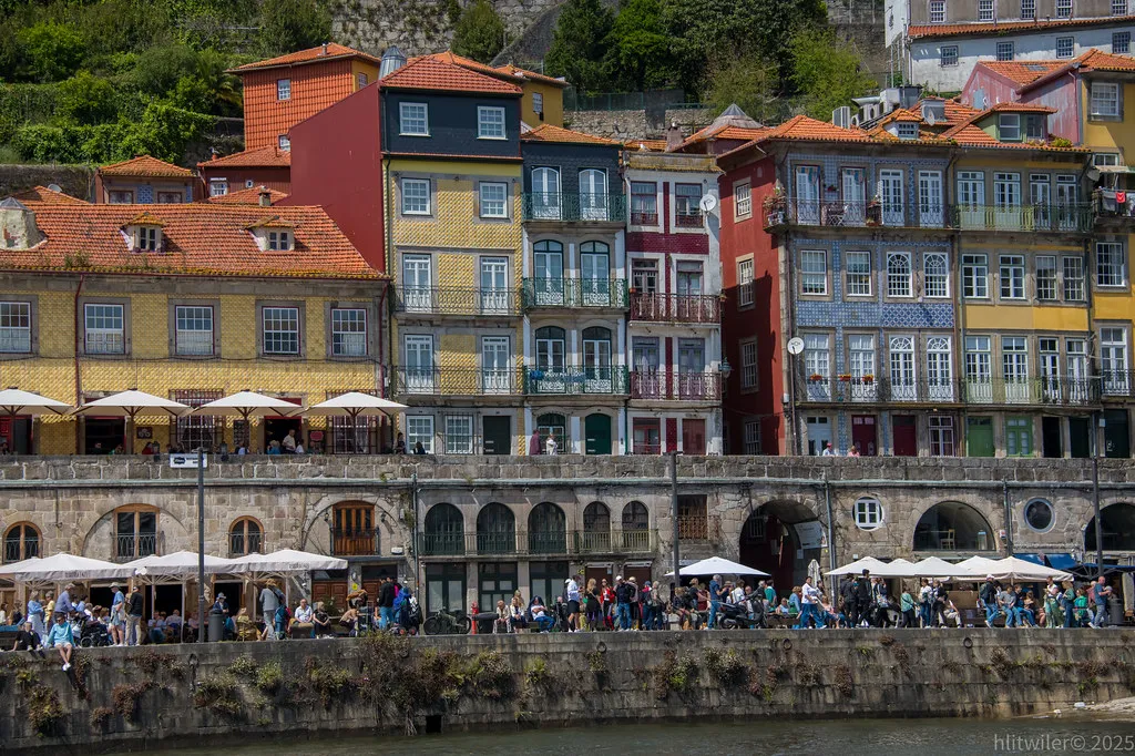
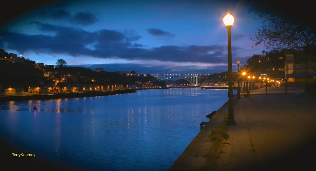
Once fully inside Portugal, the river descends through the terraced wine country and eventually broadens as it approaches Porto. The final kilometres before the Atlantic mouth pass between the city of Porto on the north bank and Vila Nova de Gaia on the south. The journey concludes at Foz do Douro, where the river meets the ocean.
Duero vs. Douro: Understanding the Name Change at the Border
The river undergoes a linguistic shift as it crosses from Spain into Portugal. In Spain, the name Duero is used, while the Portuguese call it the Douro. Both names share a root in the Latin Durius, which itself likely derives from a pre-Roman Celtic or Iberian term relating to water.
Beyond the name, the character of the river changes noticeably across the border. The Spanish Duero flows through high-altitude plains and moves through broad agricultural landscapes. In Portugal, the river is hemmed in by steep schist hillsides covered in terraced vineyards that descend almost to the water's edge.
The wine cultures are also distinct on each side. Spain's Ribera del Duero produces full-bodied red wines mainly from Tempranillo, earning its own denominación de origen in 1982. Portugal's Douro produces table wines and the fortified Port wine, in a region that was the world's first legally demarcated wine zone, established in 1756. You can find more information about these cultural nuances on the Portugal Wander blog.
- Spanish Duero: approximately 572 km, flowing through Castilla y León, famous for Ribera del Duero wines and Romanesque cathedral cities.
- Portuguese Douro: approximately 325 km, flowing through the Norte Region, famous for Port wine and the UNESCO Alto Douro Wine Region.
The International Douro Natural Park: Where the Canyon Defines the Border
Between the Portuguese town of Miranda do Douro and the Spanish town of Arribes del Duero, the river drops through a deep canyon that is jointly protected by both countries. Portugal calls its side the Parque Natural do Douro Internacional; Spain calls its portion the Parque Natural de Arribes del Duero. Together they form one of the most biodiverse and least-visited landscapes on the Iberian Peninsula.
The canyon walls drop 200 metres or more in places, creating a microclimate warm enough to support olive groves and almonds at altitude. Migratory birds use the thermal currents rising from the gorge. Rare plant species found here are absent from anywhere else in Portugal. The area also contains megalithic standing stones and Iron Age hill forts that are almost entirely overlooked by mainstream tourism.
Miranda do Douro itself is worth a visit for reasons beyond the river. The town speaks Mirandese, a recognised regional language descended from old Leonese dialect that is related to but distinct from Portuguese. Fewer than 15,000 people speak it worldwide. The Saturday market is lively and the local chouriça sausage is a regional speciality.
Getting to the park requires a car; public transport does not reach the canyon viewpoints. The drive from Bragança takes about 45 minutes. Several scenic belvederes such as São João das Arribes overlook the gorge and offer views into Spain from the Portuguese side.
Rabelo Boats, Dams, and the Locks That Move Cruise Ships Uphill
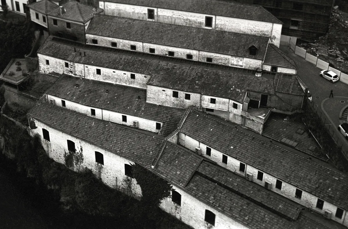
Historically, the Portuguese Douro was a dangerous waterway studded with cataracts and rapids. Flat-bottomed Rabelo boats — shallow-draughted, high-sterned vessels — were designed specifically to navigate these conditions. Crews of six to eight men poled and rowed barrels of Port wine from the upstream quintas down to the lodges in Vila Nova de Gaia, a journey that could take days and sometimes ended in disaster.
Between 1958 and 1985, Portugal built five large dams on the Portuguese stretch of the Douro, ending the era of the wild river entirely. Those dams are Carrapatelo, Crestuma-Lever, Bagaúste, Régua, Valeira, and Pocinho — six structures in total on the Portuguese side, with Carrapatelo's lock being the tallest river lock in Europe at 35 metres. Each dam also created a reservoir that submerged much of the old river landscape, including several ancient villages that were relocated before the waters rose.
The lock system is what makes modern Douro cruises possible. Cruise ships enter a lock chamber, the gates close, and water levels adjust — raising or lowering the vessel up to 35 metres in a matter of minutes. Passengers stand on deck and watch the canyon walls slide past as the ship climbs. The lock experience at Carrapatelo, between Régua and Porto, is consistently cited by cruise passengers as one of the most memorable moments of the journey.
Rabelo boats still exist but serve a ceremonial role. You can learn about the impact of these changes on 10 Best Douro Valley Tourism Attractions today. The boats are moored along the Gaia quay and used for short sightseeing trips or displayed during the annual São João festival in Porto each June.
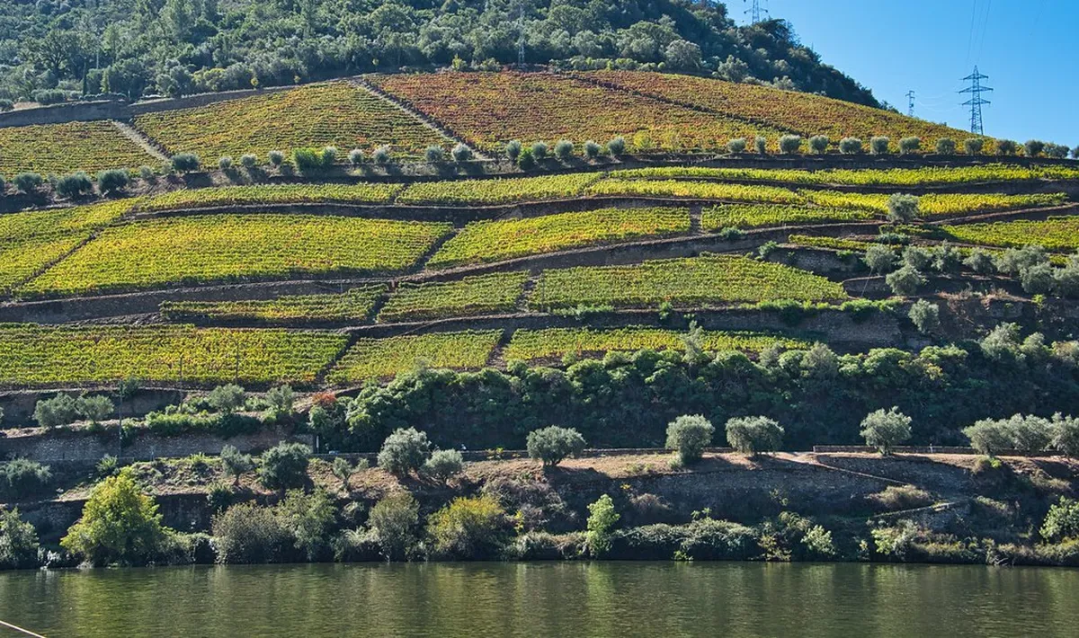
The Douro Valley: Port Wine and UNESCO Heritage
The UNESCO World Heritage - Alto Douro Wine Region is the most celebrated part of the river's Portuguese stretch. Humans have shaped these steep schist hillsides into productive terraces for over two thousand years. UNESCO inscribed the landscape in 2001, recognising it as a remarkable example of a living, working cultural landscape rather than a historical relic.
The specific combination of schist rock, south-facing slopes, and low annual rainfall creates conditions ideal for indigenous grape varieties like Touriga Nacional, Touriga Franca, and Tinta Roriz. These grapes produce both high-quality unfortified table wines and the world-famous Port wine. The Douro was the first wine region in the world to be legally demarcated, a boundary set by the Marquis of Pombal in 1756.
Visitors can immerse themselves in the history of the 10 Essential Tips for Visiting Alto Douro Vinhateiro by visiting local quintas. Many estates offer cellar tours and tastings, some requiring advance booking, especially during harvest season in September and early October. The connection between the river microclimate and the wine in the glass is something guides explain well at almost any quinta.
The Alto Douro Wine Region: 8 Essential Things to Know remains a pillar of Portugal's economy and cultural identity. Preserving the ancient dry-stone terraces requires constant manual labour and traditional masonry skills that are increasingly difficult to find. Several quintas now partner with vocational schools to train young workers in terrace maintenance.
Key Cities and Landmarks Along the Douro
The river passes through several historic urban centres that have been shaped by its presence over centuries. On the Spanish side, Zamora's 12th-century Romanesque cathedral and Salamanca's university city both sit within easy reach of the river. These cities offer a quieter alternative to the more visited Portuguese valley towns.
In Portugal, the river flows past several charming 10 Best Towns in the Douro Valley to Visit including Pinhão and Peso da Régua. Pinhão is especially famous for its early 20th-century train station decorated with 24 panels of blue-and-white azulejo tiles depicting the harvests and traditions of the valley. Peso da Régua serves as the main logistics hub for cruises and has a regional wine museum worth an afternoon visit.
Porto stands at the river's mouth as its most famous landmark. Across the water lies Vila Nova de Gaia, where the great Port wine lodges age their barrels in long low warehouses just metres from the river. The Dom Luís I Bridge, completed in 1886, connects these two cities with a double-deck iron arch that carries road traffic above and a metro line on the upper level.
Smaller villages like Miranda do Douro and Freixo de Espada à Cinta offer a glimpse into the traditional life of the border region. Each stop along the river's path reveals a different chapter of the Iberian story, from megalithic monuments to baroque churches to contemporary wine architecture.
How to Visit the Douro's Source and Valley
Travelers interested in the river's origin should head to the village of Duruelo de la Sierra in the province of Soria. This mountain village serves as the primary gateway for hiking to the Pico de Urbión. The trail to the Laguna Negra is well-marked and takes about 1.5 hours from the car park at La Vinuesa; the additional climb to the source spring adds another two hours. The hiking season runs from late May through October, when the upper paths are clear of snow.
For those who prefer a more relaxed experience, river cruises departing from Porto or from Peso da Régua are the most popular option in 2026. Cruises range from half-day excursions between Porto and Régua to seven-night luxury voyages deep into the valley. Pricing for a full-week cruise on a small ship typically starts around 1,500 EUR per person in shoulder season. Seeing the terraced hills from the water — and passing through the Carrapatelo lock — provides a perspective no road trip can replicate.
The best months to visit the valley are April to June and September to November. Spring brings blooming almond blossoms and lush green hillsides. September and October bring the vindima harvest, when quintas hire hundreds of pickers and the air smells of fermenting grape must across the entire valley. Summer is hot — Pinhão regularly exceeds 40°C in July and August — and cruise boats are crowded.
Renting a car allows flexible exploration of the miradouros and smaller villages that cruise itineraries skip. The N222 road along the south bank between Régua and Pinhão is frequently cited as one of the most scenic drives in Europe. Budget at least three full days in the valley to visit more than one quinta, catch a boat segment, and reach at least one hilltop viewpoint at sunset.
The best months to visit the Douro Valley are April to June and September to November. Summer temperatures in Pinhão regularly exceed 40°C in July and August, and cruise boats are crowded. The September and October harvest season brings the most atmospheric experience.
Frequently Asked Questions
Where exactly in Spain does the Douro start?
The Douro River starts at the Pico de Urbión in the province of Soria, Spain. This source is located within the Serra de Urbión mountain range at an elevation of 2,160 meters. Natural springs and snowmelt at this high altitude form the beginning of the river's 897-kilometer journey.
Is the source of the Douro River accessible to tourists?
Yes, the source is accessible via hiking trails starting from the village of Duruelo de la Sierra. The hike is considered moderate in difficulty and takes several hours to complete. It is best visited during the warmer months when the mountain paths are clear of snow and ice.
How long is the Douro River from source to mouth?
The Douro River is approximately 897 kilometers long from its source in Soria to its mouth in Porto. About 572 kilometers of the river flow through Spain, while the remaining 325 kilometers are in Portugal. This makes it one of the most significant waterways on the Iberian Peninsula.
What is the difference between the Duero and the Douro?
Duero is the Spanish name for the river, while Douro is the Portuguese name. Beyond the name, the Spanish side is characterized by high plateaus, while the Portuguese side is famous for steep, terraced vineyards. Both regions are world-renowned for their distinct wine production styles.
The Douro River is a remarkable waterway that connects the high peaks of Spain with the Atlantic coast of Portugal. From its humble beginnings at the Pico de Urbión, it grows into a powerful force that has shaped history and culture across two countries. Whether you are hiking past the Laguna Negra toward the actual source spring, passing through a 35-metre lock on a cruise ship, or sipping wine on a quinta terrace above Pinhão, the river offers endless depth.
Understanding where the river starts provides a complete picture of this unique European landscape. The transition from the austere Soria mountains through the deep International Douro canyon to the refined vineyards of the Alto Douro is a journey worth experiencing in full. We hope this guide helps you plan your own adventure along the 'River of Gold.'

 Roman Temple of Évora (Temple of Diana) GuideJune 8, 2026