
17 Best Hidden Beaches and Secret Spots in the Algarve (2026)
Discover the 17 best hidden beaches and secret spots in the Algarve. Explore secluded coves, sea caves, and quiet villages with our expert local tips.
On this page
17 Best Hidden Beaches and Secret Spots in the Algarve
After five years of exploring the rugged southern coast of Portugal, I have learned that the most rewarding views require a bit of sweat. While many travelers flock to the famous golden arches of Marinha, the true magic lies in the limestone cracks and sandy inlets that GPS often ignores. This guide focuses on those quiet corners where the Atlantic breeze is the only thing you will hear.
Updated for 2026, this list reflects current access conditions and local environmental regulations, including the recently approved Co-management Plan (2025–2028) for the Southwest Alentejo and Vicentine Coast Natural Park (PNSACV). I recently revisited the western cliffs and noticed several new path markers that make these 'secret' spots slightly safer for determined hikers. Finding a hidden beaches algarve secret spot is easier when you know which dirt tracks to trust.
You should consider skipping the Benagil Cave during the peak hours of 11 am to 3 pm in July and August. The sheer volume of kayaks and tour boats turns this natural wonder into a crowded parking lot that loses its mystical charm. Instead, look toward the lesser-known sea caves near Alvor or the wilder bays of the Costa Vicentina, where natural-park protection keeps development permanently at bay.
Costa Vicentina: The Wild West's Best Hidden Beaches
The Costa Vicentina — protected since 1995 as part of the Southwest Alentejo and Vicentine Coast Natural Park — is the most intact stretch of coastline in western Europe. No high-rises, no beach bars, no parking lots paved over dunes. The ICNF (Instituto da Conservação da Natureza e das Florestas) actively manages visitor pressure here, which is exactly why these beaches stay uncrowded. From Lagos, allow 90 minutes to reach the northern end near Odeceixe.
Praia da Bordeira, near Carrapateira, is the most dramatic entry point. A free car park sits just past the O Sítio do Rio restaurant, with a second upper lot up the hill when the lower fills. From there it is a 15-minute walk across dunes to a vast bay where a river empties into the Atlantic, creating a shallow lagoon ideal for children who find the ocean too rough. Surfers occupy the southern end; walkers claim the northern cliffs for themselves.
Praia da Cordoama, a few kilometres further south toward Vila do Bispo, has a marked car park off the EN268 and a short 10-minute descent on a compacted dirt path. The beach faces west, catching the afternoon light and the full force of Atlantic swells. This makes it spectacular for watching but challenging for swimming — conditions that naturally self-select the crowd. Arrive before 09:00 in July or August for any chance of solitude.
Praia do Telheiro sits between Sagres and Vila do Bispo on a bend locals call the 'elbow of Portugal.' A rough 4km track off the N268 leads to a small car park above the cliffs. The final 200m descent is unmarked and loose underfoot — use the worn chalk-coloured groove in the rock face and keep well back from the crumbling edges. No facilities of any kind; bring everything you need including fresh water.
Central Algarve: Concealed Coves and Tunnel Beaches
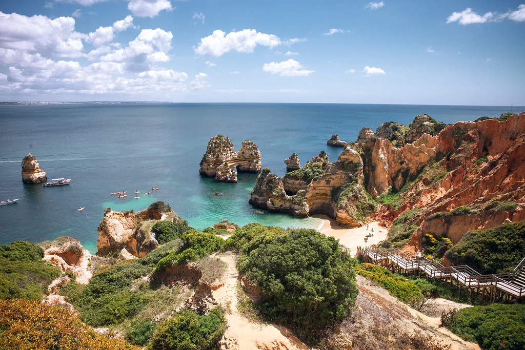
Between Lagos and Albufeira the limestone cliffs have been carved by the Atlantic into a labyrinth of coves, stacks, and arches that most coach-tour itineraries skip entirely. The beaches in this stretch are smaller — some hold fewer than 50 people comfortably — which is both the problem and the point. Checking Visitalgarve's coastal trail map before you leave will save time locating trailheads.
Praia do Carvalho is the standout find of the central coast. To reach it you pass through a tunnel carved directly into the cliff face — roughly 40m long, dark in the middle, and just wide enough for two adults shoulder-to-shoulder. The tunnel exits onto a small sandy cove ringed by sheer limestone walls that block direct sun until late morning. There are no facilities, no lifeguard, and the tunnel floods at high tide, so check conditions before you descend. It sits near Benagil, signposted off the EN125 at Lagoa.
Praia das Furnas lies 20 minutes from Sagres by car, reached via the village of Figueira and then 2.5km of unpaved road that ends at a free car park above the beach. The beach itself wraps around a series of small sea caves — 'furnas' means caves in Portuguese — that have eroded into the base of the cliffs. At low tide the cave interiors are walkable; at high tide they fill to the ceiling. The cave acoustic on a swell day is extraordinary and worth the bumpy drive alone.
Arco de Albandeira provides a singular limestone sea arch over the Atlantic, quieter than Marinha despite being only 6km apart. The beach below disappears at high tide, so most visitors stay on the clifftop path for photography. The late afternoon light turns the arch a deep amber — arrive about 60 minutes before sunset for the best colour.
Praia do Barranco and Praia do Camilo (semi-hidden) round out the central section. Praia do Camilo requires descending 200 wooden steps built into the cliff, which deters enough visitors to keep it noticeably quieter than nearby Dona Ana. Pack water shoes; the shoreline has sharp limestone fragments at the waterline.
| Beach | Region | Access | Facilities | Best For |
|---|---|---|---|---|
| Praia da Bordeira | Costa Vicentina | Free car park, 15-min walk | None | Families, walkers |
| Praia da Cordoama | Costa Vicentina | Marked car park off EN268, 10-min descent | None | Sunset watching |
| Praia do Telheiro | Costa Vicentina | 4km rough track, small cliff-top car park | None | Solitude seekers |
| Praia do Carvalho | Central Algarve | 40m cliff tunnel, near Benagil off EN125 | None | Adventure, photography |
| Praia das Furnas | Central Algarve | 2.5km unpaved road, free car park | None | Cave exploration |
| Ilha da Culatra | Eastern Algarve | Ferry from Olhão (~€4 return) | Fishing village nearby | Swimming, terns |
| Cacela Velha | Eastern Algarve | Wade at low tide across lagoon | Local restaurant | Oysters, sandbar walks |
Eastern Algarve: Island Beaches and Lagoon Secrets
The Sotavento coast, from Faro east to the Spanish border, trades limestone drama for barrier islands and warm, calm water. The Ria Formosa Natural Park protects this entire coastline, keeping it undeveloped and, in parts, genuinely remote. Ferry crossings range from €2–€5 return and run frequently enough that you rarely wait more than 20 minutes.
Ilha da Culatra's eastern tip is the reliable Eastern Algarve escape: no cars, a fishing village of wooden-hulled boats, and long dune-backed beaches that end in sand you share only with terns. Ferries depart regularly from Olhão for roughly €4 return. Walk at least 25 minutes past the village to clear the cluster of day-trippers who turn back at the first stretch of open sand.
Cacela Velha is a whitewashed cliff-top hamlet where the view over the Ria Formosa lagoon is worth the detour alone. At low tide you can wade across knee-deep water to reach the outer sandbar beaches, which are among the least-visited in the Algarve. The local restaurant serves oysters harvested directly from the lagoon below — the only beach-adjacent meal in this list that justifies arriving hungry.
Castro Marim, near the Spanish border, is not a beach at all but a network of ancient salt pans and marshland that flamingos use as a seasonal staging point. They pass through predominantly between November and March. The surrounding wetlands are free to walk and the lack of any tourist infrastructure means you have them almost entirely to yourself outside the brief flamingo peak.
Inland Secrets Worth Pairing with a Beach Day
The heat at peak summer makes a mid-day cultural detour practical rather than optional. Pego do Inferno, a waterfall and emerald pool near Tavira, is best visited before May — water levels drop sharply from June onward as the dry season sets in. The path is short but overgrown; wear shoes rather than sandals. Castle of Paderne is a ruined Moorish castle on a lonely hilltop accessed by a two-hour circular walk past a Roman bridge. Entry is free and the site is rarely visited even in August. The Loulé Islamic baths — the only well-preserved hammam in Portugal — open Tuesday through Saturday, with adult tickets around €4. Combining a Saturday morning visit with the Loulé municipal market makes for a full half-day cultural programme.

The Roman site at Milreu (Estoi) adds a third dimension: fish mosaics, bathing complexes, and the adjacent Rococo palace of Estoi for contrast. Open daily from 10:00–18:00, entry around €3. These inland stops share a characteristic worth noting: they are almost always deserted by 14:00 when visitors return to the beach, meaning the second half of the afternoon is the most peaceful time to visit.
How to Find the Best Algarve Beaches (Local Tips)
The most important tool for any beach explorer in Portugal is a reliable tide chart application. Many of the secret coves mentioned above, like Praia do Carvalho and Praia das Furnas, are inaccessible or dangerous at high tide. I once spent three hours waiting for the tide to recede at a hidden spot only to realize the path was too slippery.
Praia do Carvalho's tunnel floods at high tide — always check tidal conditions before descending. May, June, and September offer the best balance of warm water and thinner crowds for exploring these secret spots.
Consulting the best time to visit Algarve guide will help you avoid the crushing August crowds. May, June, and September offer the perfect balance of warm water and manageable tourist numbers for exploring. The Algarve weather by month varies significantly, with winter months bringing swells that make cave exploration dangerous.
Renting a small car is almost mandatory for reaching the trailheads of the more secluded western beaches. While you can use the Algarve by train or bus for major towns, public transit rarely reaches the coast — the Vamus Bus 79 (Lagos to Odeceixe) is the only service near Costa Vicentina, and it stops at villages, not beaches. Always carry a physical map or download offline Google Maps, as cell service drops frequently behind the high limestone cliffs.
What the Natural Park Rules Mean in Practice
Most visitors to Costa Vicentina beaches do not realise they are inside a protected area governed by the ICNF. The park's Co-management Plan (2025–2028) introduced stricter controls on free camping and off-road vehicle access, both of which were causing cliff erosion at beaches like Bordeira and Murração. In 2026 the practical result is straightforward: park only in designated car parks, stay on marked paths, and do not camp outside permitted zones. Wild camping is prohibited across the entire park perimeter.
Wild camping is prohibited across the entire Costa Vicentina Natural Park perimeter. The ICNF also imposes seasonal nesting closures on cliff sections between February and July — respect orange rope barriers and follow posted alternative routes.
The Rota Vicentina — the official long-distance trail authority — maintains 450km of walking routes along this coast, several of which give the best legal access to beaches with no other path. The Fishermen's Trail section between Odeceixe and Sagres passes the most beach access points of any trail in Portugal. Walking even a short section (Bordeira to Carrapateira is 12km) is the most responsible way to reach the remotest coves without damaging the protected dune ecosystem.
One detail no competitor guide mentions: the ICNF imposes seasonal nesting closures on specific sections of cliff above Costa Vicentina beaches between February and July, protecting peregrine falcons and Bonelli's eagles. These closures affect the climbing approach at Praia das Furnas most directly, but the beach itself remains open. If a section of path is roped off with orange fencing, it is a nesting buffer — there is always an alternative route posted nearby. Respecting these buffers keeps the closures temporary rather than permanent.
Is the Costa Vicentina Worth the Drive?
The drive from Faro to the western coast takes about 90 minutes, which deters many casual day-trippers. This region is part of the Southwest Alentejo and Vicentine Coast Natural Park, ensuring that high-rise hotels and neon signs remain absent. You will find vast, footprint-free bays like Praia da Bordeira and Praia da Cordoama that offer a stark contrast to the busy Lagos coves.

If you prefer calm, warm waters for swimming, the west coast might actually be a disappointment. The Atlantic here is much colder and the waves are significantly larger, making it better for hiking and surfing. Many visitors find the raw power of the ocean here to be the highlight of their entire Portuguese holiday.
For those staying in the central area, a day trip to the west provides a refreshing change of scenery. Stop in the town of Aljezur — whose municipality administers much of the Costa Vicentina coastline — for a traditional sweet potato pastry before heading to the cliffs. The lack of infrastructure means you must bring all your supplies, as beach bars are a rarity in this wild territory.
Frequently Asked Questions
Which part of the Algarve has the best hidden beaches?
The central region between Lagos and Albufeira has the best limestone coves, while the west coast offers the most seclusion. For quiet island escapes, the eastern Algarve near Tavira is unbeatable. Each area requires different levels of effort to access.
How do I safely visit secret sea caves?
Always visit during low tide and check the swell forecast before entering any cave by water. Kayaking or paddleboarding is safer than swimming, especially in areas with boat traffic. Never enter a cave if the sea looks rough or unpredictable.
Are there any secret beaches near Lagos?
Yes, while best beaches in Lagos Portugal are popular, spots like Praia do Carvalho (accessed through a cliff tunnel near Benagil) and Praia das Furnas are within 45 minutes. Most visitors stick to the easily accessible sands of Dona Ana or Camilo.
Pair this with our broader guide to the best beaches in the Algarve for the full coastal overview. Exploring the hidden side of the Algarve requires patience and a sense of adventure that goes beyond the standard tourist trail. Whether you are wading through the lagoons of Cacela Velha or descending through the tunnel at Praia do Carvalho, the effort is always rewarded. The beauty of this region lies in its diversity, from the wild Atlantic waves to the silent Moorish ruins inland.
Remember to respect the local environment by packing out all your trash and staying on marked trails to prevent erosion. The secret spots of the Algarve remain special only as long as we treat them with the care they deserve. I hope this guide helps you find your own private slice of paradise under the Portuguese sun.
For related Algarve beach deep-dives, see our Praia Do Carvalho Benagil Travel Guide and Sagres From Lagos Day Trip Travel Guide guides.