Mount Pico Hike Azores: 9 Things to Know Before You Climb
Plan your Mount Pico hike in the Azores with this expert guide. Covers permits, Casa da Montanha logistics, packing for volcanic terrain, and the Piquinho summit.
On this page
Mount Pico Hike Azores: 9 Things to Know Before You Climb
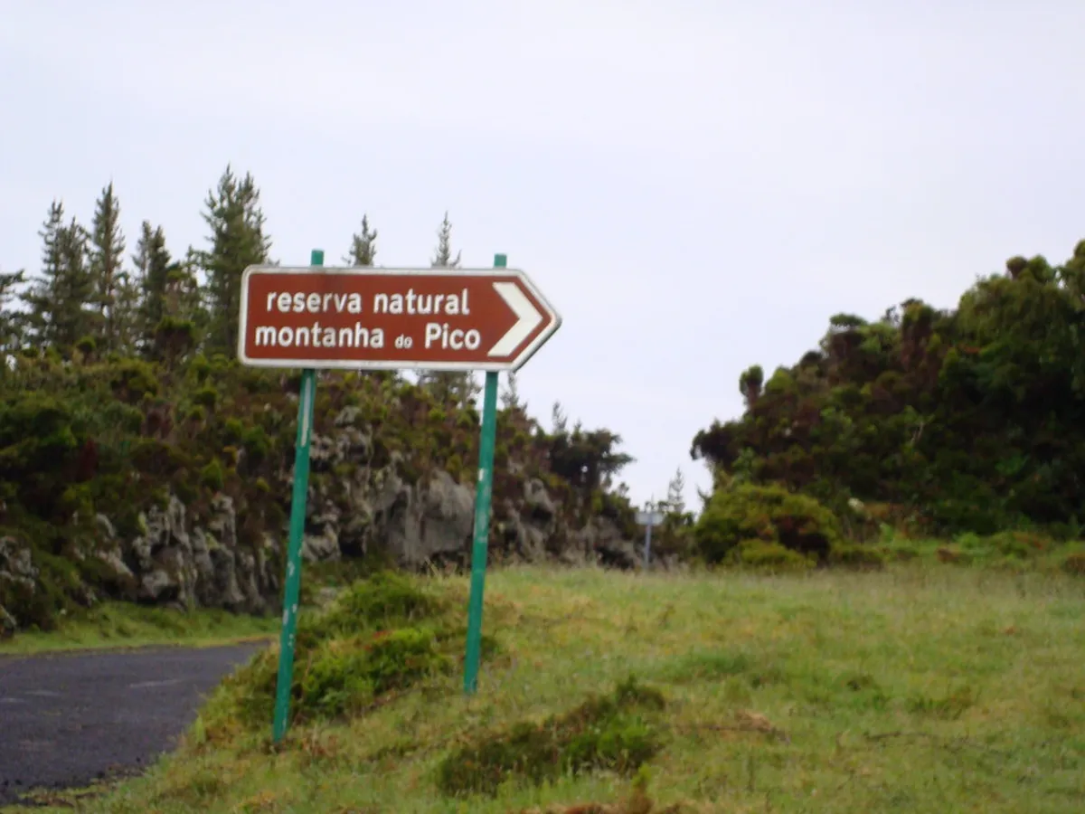
Mount Pico stands as the highest point in Portugal and offers a legendary challenge for adventure travelers. This massive stratovolcano rises 2,351 meters directly from the Atlantic Ocean on Pico Island. Planning a successful mount pico hike azores requires careful preparation and an understanding of local regulations. Knowing How To Get To Azores Travel Guide is the first step in reaching this iconic peak.
The trail is famous for its steep inclines and sharp volcanic rocks that test your endurance. Hikers often face rapidly changing weather conditions that can obscure the path in minutes. Completing the ascent rewards you with breathtaking views of the neighboring islands in the central group. This guide provides the essential details you need to conquer the summit safely in 2026.
Mount Pico Hike: Essential Stats and Difficulty Level
The climb begins at the mountain house, situated at an altitude of 1,200 meters. You must gain another 1,151 meters of elevation to reach the true summit. This steep ascent occurs over a horizontal distance of roughly 5 kilometers to Piquinho. Most hikers should budget between seven and nine hours for the full round trip, including time at the crater.
Terrain on the mountain consists primarily of loose scree and jagged basalt rocks. Up to marker 22 you are mostly walking on broad lava flows, which are slippery when wet. Above marker 22 the ground shifts to smaller volcanic gravel and loose rock, demanding constant foot placement attention. The difficulty is rated strenuous because there are virtually no flat sections for recovery.
Markers numbered 1 through 47 indicate your progress along the official trail. These wooden posts are spaced out to help you stay on course during low visibility. Reaching marker 44 brings you to the rim of the main crater — a genuine milestone. From there, the final 70-meter scramble up Piquinho awaits the most determined climbers.
- Trailhead: Casa da Montanha at 1,200 m elevation
- Summit: Piquinho at 2,351 m (Portugal's highest point)
- Total elevation gain: approximately 1,151 m
- Return distance: 7.6 km
- Average round-trip time: 7–9 hours
- Difficulty: strenuous
About one third of hikers who start the ascent do not reach the summit. Most turn back due to weather, fatigue, or inadequate footwear — all of which are avoidable with good planning.
Getting There: Reaching Pico Island and the Trailhead
Reaching Pico Island is straightforward via a short inter-island flight or the fast ferry from Faial. SATA/Azores Airlines runs daily connections from Lisbon (around 2h30) and from São Miguel. Many travelers choose to stay on Faial and take the morning boat to Madalena, which crosses in roughly 30 minutes. You can explore more about Faial island activities to plan your regional transit alongside the hike.
The trailhead is located at Casa da Montanha, roughly a 20-minute drive from Madalena. A rental car is the most flexible option and strongly recommended — public transport does not serve the trailhead. Book your car months in advance if you are visiting between June and August; availability disappears fast, and some hikers have had to resort to taxis or scooters. Taxis are a reliable fallback; book a return pickup in advance since phone signal can be unreliable at altitude.
Parking is available at the visitor center. The lot fills quickly on clear mornings in high season, so arriving before 07:00 gives you both a parking spot and the best chance of clear skies. You can find more things to do on Pico to round out your visit to the island beyond the mountain itself.
Booking and Permits: Navigating the Casa da Montanha System
Access to the mountain is strictly regulated to protect the environment and ensure hiker safety. You must register and pay a fee at the visitor center before starting your climb. In 2026, the fee is €25 to hike all the way to Piquinho, or €15 if you plan to stop at the crater rim. Check the Azores Nature Park authority for the latest fee schedule before you travel.
Every hiker receives a mandatory GPS tracker that must be carried throughout the entire journey. This device allows staff to monitor your location every minute and respond quickly to any emergencies. If you deviate significantly from the trail, the ranger team at Casa da Montanha can contact or intercept you. You must return the tracker immediately upon descending to the mountain house.
There are two ways to get your permit. You can book online via the official website in advance, which guarantees your slot and is essential during July and August when capacity fills weeks ahead. Alternatively, Casa da Montanha operates on a 24-hour basis in summer and offers daily walk-in spots on a first-come, first-served basis. If you want flexibility to choose the clearest weather day, arrive by 07:00 to secure a walk-in slot. If you are joining a guided tour, the agency handles all permit logistics for you.
In 2026, the permit fee is €25 to reach Piquinho or €15 to stop at the crater rim. Online bookings guarantee your slot — essential in July and August when capacity fills weeks ahead. Walk-in spots are available daily on a first-come, first-served basis for those keeping weather flexibility.
Boot Check: What Rangers Inspect Before You Step on the Trail
Before issuing your GPS tracker and allowing you onto the trail, rangers at Casa da Montanha physically inspect your footwear. This is not a formality. Staff examine sole thickness, tread depth, and overall condition. Anyone arriving in road sneakers, worn-out trainers with smooth soles, or sandals will be turned away — no exceptions, regardless of how far they have traveled.
The volcanic basalt on Mount Pico shreds thin soles and offers no grip on wet rock. High-ankle hiking boots with a lugged rubber sole are the clear choice. Trail runners occupy a grey area: a well-maintained trail runner with deep tread can pass the check, but a standard road-to-trail shoe with a thin midsole almost certainly will not. When in doubt, bring boots rather than risk the rejection.
Trekking poles are not mandatory but earn near-universal praise from hikers on the descent, when tired legs amplify the impact on knees. Gloves are worth carrying even in summer — the upper sections are exposed to wind and the Piquinho scramble requires using your hands on rough rock. Pack them rather than leave them at the hotel.
Guided vs. Unguided: Which Climbing Option is Best?
Choosing between a guided or unguided climb depends on your experience and comfort with volcanic terrain. Confident hikers with mountain experience and good weather can manage the trail independently — the 47 numbered markers provide clear navigation in fair visibility. However, in thick cloud the path above marker 30 becomes difficult to read and experienced guides know the shortcuts and shelters that are invisible to first-timers.
Guides offer the most value at two specific moments: when the weather is closing in around marker 15–20 (a common turnaround point for unguided groups who lose nerve) and during the Piquinho scramble, where the obvious trail disappears. A good guide also limits group size; choose operators with a maximum of eight people, as large groups of 15 move slowly and the slowest member sets the pace. You can find guided options via Tripx Azores or local agency Atípico, both operating small-group climbs.
For night climbs and sunrise hikes, a guide is mandatory under current park regulations. These experts ensure you navigate the dark trail safely with headlamps and arrive at the summit on schedule. Going solo without a guide on a daytime climb is perfectly legal and entirely viable for fit, experienced hikers — just be honest about your abilities before committing. You can also browse hiking trails across the Azores to gauge how your fitness compares to other regional climbs.
The Ascent: A Step-by-Step Guide to the Summit
The first third of the hike passes through low-lying scrub and grassy patches on broad lava flows. Pace yourself here — the incline feels manageable early on, but the continuous steepness accumulates fast. As you climb above marker 20, vegetation disappears completely and the landscape shifts to dark volcanic rock. The incline becomes significantly steeper after marker 24; this is where many hikers first question whether they will make it.

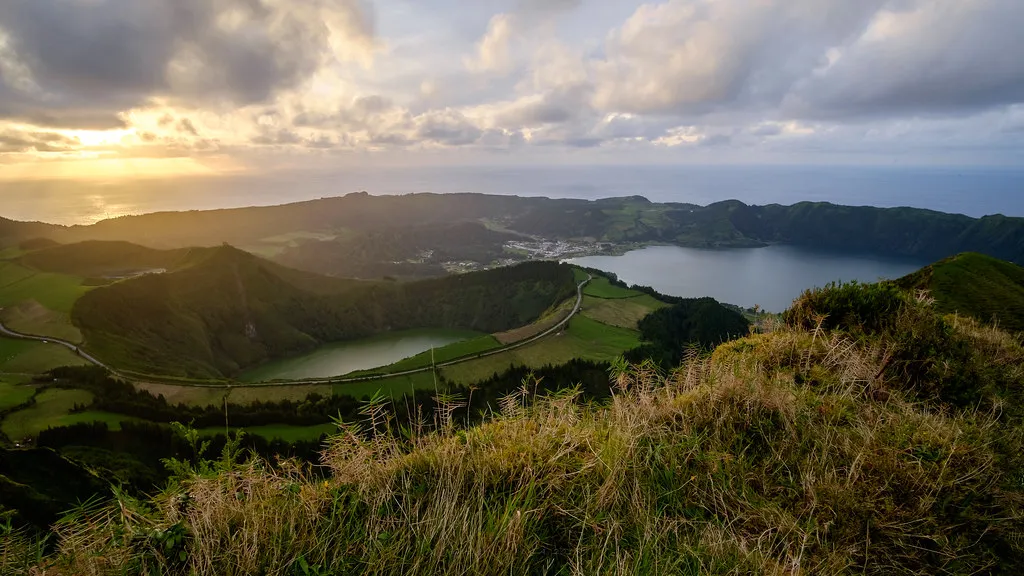
Reaching the crater rim at marker 44 is a major milestone that offers a genuine sense of achievement. The crater floor is surprisingly large and contains various geological formations, stone wind-shelters built by previous climbers, and occasional steam rising from fumaroles — a reminder this volcano is dormant, not extinct. Take a rest here and refuel before the final challenge.
The Piquinho is a small cone that rises 70 meters above the crater floor. Above the first few red and yellow poles, there is no marked trail — the ascent is borderline rock-climbing, requiring hands for balance and a tolerance for exposure. Note that park regulations limit time on the Piquinho peak to 20 minutes per group, to ensure everyone gets a turn. Once at the very top you can feel heat rising from volcanic vents between the rocks — the underlying magma is far closer to the surface here than anywhere else in Portugal. The 360-degree views of Faial, São Jorge, and the open Atlantic are unforgettable on a clear day.
The Descent: Why Going Down is Harder Than Going Up
Most hikers are surprised to find the descent more punishing than the ascent. Mentally, the goal is gone; physically, your quads and knees absorb repeated impact on the same uneven rocks for three to four hours straight. Fatigue and mild drowsiness set in quickly above the crater on the way down, making foot placement errors more likely. Slow down deliberately, especially on the loose scree sections above marker 20.
Trekking poles pay their biggest dividend on the descent. Without them, most hikers grip rocks, grab low vegetation, and try to distribute impact by angling sideways down steep sections. With them, you have two additional contact points and far less strain on the knees. If you did not bring poles, take your time — this is where twisted ankles and falls happen most frequently.
The total round trip for most fit hikers is nine hours including stops. Budget at least three to four hours for the descent alone. By the time you reach the visitor center you will have very little left in the legs; plan a short recovery evening at your base and avoid scheduling a ferry or flight for the same afternoon.
Overnight on the Mountain: The Sunrise Option
Staying overnight in the crater is one of the most memorable ways to experience Mount Pico. Sunset and sunrise at 2,351 meters, with a sea of clouds below and neighboring islands emerging from the horizon, is a completely different experience from the daytime hike. The night sky from the crater is exceptional — Pico Island has minimal light pollution and the altitude keeps you above most atmospheric haze.
The logistics are stricter than a standard day hike. Overnight permits are more limited than daytime slots; book well in advance through Casa da Montanha, especially for July and August weekends. A tent is mandatory — the stone wind-shelters built by other hikers are not a substitute. Bring a sleeping bag rated for 0°C or below, even in summer. Temperatures inside the crater regularly drop to near-freezing overnight, and wind can be relentless. Extra insulating layers, a headlamp, and additional food and water are all required items.
Guided sunrise climbs start at Casa da Montanha around midnight, arriving at the crater for the 05:30–06:00 sunrise window. This option removes the logistics burden and is the safest approach for anyone unfamiliar with night navigation on unmarked volcanic terrain. Solo overnight stays are permitted but require you to be fully self-sufficient; the ranger team monitors GPS trackers throughout the night and the mountain can be closed even mid-stay if conditions deteriorate sharply.
Packing Essentials: Gear for Volcanic Terrain
Proper footwear is the most important piece of equipment for this specific mountain, and it is non-negotiable at the ranger inspection point. You need sturdy hiking boots with thick, lugged soles and good ankle support to handle the loose rocks. Trail runners are borderline — only bring them if they have deep tread and you have hiked in them on rough terrain. Standard road-to-trail shoes will likely fail the ranger inspection at Casa da Montanha before you even reach the trail.
Weather on Mount Pico is notoriously unpredictable and can change within minutes. Use a layering system: moisture-wicking base layer, insulating mid-layer, and a waterproof windproof shell. Even in July, the summit temperature can be 10–15°C cooler than Madalena. A warm hat and lightweight gloves should be in your pack regardless of the forecast — you will need them on the Piquinho scramble at minimum.
Water and nutrition are critical for maintaining energy over the eight-to-nine-hour trek. Carry at least two to three liters of water per person; there are no water sources or facilities on the trail above Casa da Montanha. A water bladder lets you drink while moving without removing your pack. Pack energy-dense snacks (nuts, dried fruit, protein bars) and a real lunch — a cheese sandwich tastes extraordinary at 2,300 meters. Add a headlamp even for day hikes in case your descent runs later than expected.
- Mandatory: high-ankle hiking boots with deep lugged soles (inspected at Casa da Montanha)
- Water: 2–3 liters minimum
- Layers: waterproof and windproof shell, warm hat, gloves
- Trekking poles: optional on ascent, strongly recommended for descent
- Headlamp: required for night climbs; carry on day hikes as backup
- Food: packed lunch plus energy snacks for 7–9 hours
When to Hike: Best Months and Weather Safety Tips
The ideal window for climbing Mount Pico is between June and September. During these months, you have the highest probability of clear skies and dry trails. June tends to offer the best balance — high-season crowds have not yet peaked and clear-day probability is higher than in May. August is the busiest month, with accommodation and rental cars booked out months ahead. Consult the official Visit Azores website for general seasonal travel advice and current weather patterns.
Winter hiking is possible but is reserved for very experienced climbers with technical gear. Snow and ice can cover the upper slopes from November through March, making the trail extremely dangerous without crampons and ice axes. High winds are also more common during colder months, leading to frequent trail closures. Always check the mountain status directly at Casa da Montanha before attempting any out-of-season ascent.
Visibility is the biggest safety concern on this lone Atlantic peak. Mount Pico creates its own microclimate — humid Atlantic air hits the slopes, rises and cools rapidly, and dense fog can appear within 15 minutes regardless of the sea-level forecast. If the clouds become too thick to see the next marker, turn back. No summit view is worth getting lost on a 2,351-meter stratovolcano in zero visibility. The park staff can close the mountain mid-climb and will issue a GPS alert if your tracker data shows you off-trail.
Mount Pico creates its own microclimate — dense fog can appear within 15 minutes regardless of the sea-level forecast. If clouds become too thick to see the next marker, turn back immediately. The park can close the mountain mid-climb and issue GPS alerts if your tracker shows you off-trail.
Where to Stay: Best Bases for Your Pico Hiking Trip
Madalena is the most convenient town for hikers because it is closest to the mountain and the ferry port. You will find a variety of guesthouses, hotels, and restaurants catering to outdoor enthusiasts. Staying here allows you to reach the trailhead quickly for an early morning start without a long drive. Check our guide on where to stay in the Azores for more accommodation tips across the archipelago.
Sao Roque is another option on the northern coast of the island, about 30 minutes from Casa da Montanha. This town offers a quieter atmosphere and views toward São Jorge Island. It is close to the São Roque campsite and natural swimming pools, making it a good choice if you plan to extend your stay beyond the climb.
Lajes do Pico on the southern shore provides a more traditional Azorean experience. This historic whaling town is famous for its whale-watching heritage and beautiful coastal scenery. While the drive to the trailhead is longer (around 40–50 minutes), the area is a UNESCO World Heritage vineyard landscape — the unique stone-walled currais that shelter Verdelho vines stretch all the way to the ocean and make for excellent post-hike exploration. Book accommodation anywhere on the island at least two months ahead if visiting between July and August; the island fills up and car hire availability disappears simultaneously.
Frequently Asked Questions
Is the Mount Pico hike difficult for beginners?
The Mount Pico hike is considered difficult due to its steep incline and uneven volcanic terrain. Beginners should have a good level of physical fitness and proper hiking boots. It is highly recommended to take your time and follow the markers carefully. You can learn more about other Azores trails if you prefer easier options first.
Do I need a guide to climb Mount Pico?
A guide is not mandatory for daytime climbs, but they are required for overnight or sunrise hikes. Many hikers hire guides for safety and to learn about the volcano's unique geology. Guides also provide essential safety equipment and expert navigation during low visibility. Booking in advance is necessary during the peak season.
How much does it cost to hike Mount Pico?
Fees for hiking Mount Pico generally range from 15 to 25 Euros depending on how high you climb. This fee includes the mandatory GPS tracker and access to the mountain trail. Prices may change, so verify current rates at the Casa da Montanha visitor center. Guided tours will incur additional costs for the professional service.
What happens if the weather is bad on the day of my hike?
The Casa da Montanha staff may close the mountain if weather conditions become unsafe for hikers. This usually happens during high winds, heavy rain, or extremely low visibility. If your climb is cancelled, you can often reschedule for a different day if slots are available. Safety is the priority for all mountain operations.
Climbing Mount Pico is a rewarding experience that offers a unique perspective on the Azores archipelago. By following this guide, you can prepare for the physical and logistical challenges of the ascent. Remember to respect the natural environment and follow all safety protocols issued by the park authorities. A well-planned Azores itinerary will ensure you have time for this unforgettable adventure.
The memories of standing on Portugal's highest peak will stay with you long after you leave the island. Take the time to enjoy the journey and the incredible volcanic landscapes along the way. Prepare your gear, book your permit, and get ready for the hike of a lifetime.