7 Essential Tips for Visiting Lagoa Do Fogo Sao Miguel
Plan your trip to Lagoa do Fogo with our 2026 guide. Includes shuttle bus rules, hiking trail maps, viewpoint locations, and weather tips for the best views.
On this page
7 Essential Tips for Visiting Lagoa Do Fogo Sao Miguel
Lagoa do Fogo stands as one of the most untouched natural wonders in the Azores. This turquoise lake sits high within a volcanic crater on the island of São Miguel. Visitors consistently rank it among the best São Miguel Azores things to do during their stay. Its name means Fire Lagoon, which hints at its dramatic geological past.
The surrounding landscape features lush green hills and steep caldera walls. Because the area is a protected reserve, you will find very few buildings here. This isolation creates a peaceful atmosphere that contrasts with busier tourist spots. Planning a visit requires some knowledge of local weather and the 2026 transport rules, a reserve managed by the Azores Natural Parks authority.
Our guide covers everything you need for a successful trip in 2026. We explore the best viewpoints, all three ways to reach the lake shore, and the mandatory shuttle bus system. Understanding these details ensures you enjoy the scenery without any logistical stress.
Essential Facts About Lagoa do Fogo (Fire Lagoon)
The lagoa do fogo sao miguel formed inside the caldera of the Água de Pau Massif. This volcano last erupted in 1563, shaping the rugged terrain we see today. The lake sits at roughly 575 metres above sea level and measures about 2 km long by 1 km wide, covering 1,360 hectares in total. High caldera walls rise over 900 metres and wrap around the water on all sides.
The entire region has been protected as a natural reserve since 1974 and is now a Special Area of Conservation within the Azores. Endemic plants like Azorean heather and juniper thrive in this humid environment. Rare birds find sanctuary within the steep volcanic walls, and the absence of nearby farms keeps the water quality exceptionally high.
In 2012, the "Praia de Lagoa do Fogo" was recognised as one of the 7 Wonders of Portugal in the wild beach category. The recognition underlines its status as a national ecological treasure. Unlike the Sete Cidades lagoons to the west, there are no villages or roads running alongside Fogo. That remoteness is precisely what makes it special.
Geologists continue to monitor the area for volcanic and seismic activity. The volcano is considered dormant, but geothermal energy from below powers electricity generation on the island. You can feel the scale of that natural force simply by standing on the crater rim.
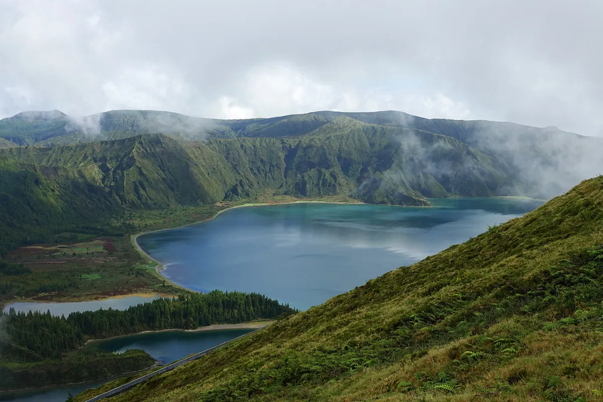
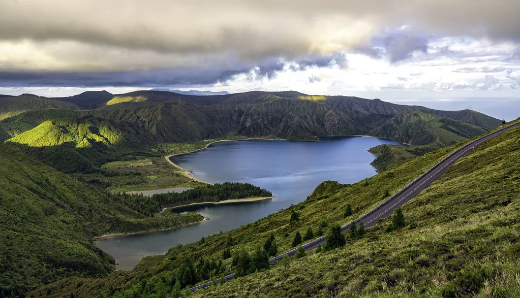
Best Viewpoints: Miradouro da Barrosa, Pico da Barrosa, and Miradouro da Lagoa do Fogo
Most visitors first see the lake from the Miradouro da Barrosa. This viewpoint offers a wide panorama of the entire crater and, on clear days, both the north and south coasts of São Miguel. The blue of the water looks especially vibrant against the dark volcanic soil. Parking here is limited, so arrive before 09:00 in summer.
Pico da Barrosa sits slightly higher along the same road. Communication towers crowd the summit but the elevation gives an even more expansive perspective of the lagoon and the Atlantic beyond. Walking between Barrosa and Pico da Barrosa takes about ten minutes and reveals different angles ideal for photography. Wind at this altitude can be fierce, so secure your camera strap.
The third viewpoint, the Miradouro da Lagoa do Fogo, is the most important one to know about. It sits on the opposite side of the crater from Barrosa and has more parking because it doubles as the trailhead for the short descent to the lake. Tour buses stop here, so it can get busier mid-morning, but it offers a different angle entirely — looking directly down onto the white sand beach at the water's edge.
Early morning light often creates a golden glow across the lagoon surface. Cloud shadows moving across the water add a sense of scale to photographs. Try to include some of the local flora in your foreground for better composition. Always park in designated areas; fines from local rangers are enforced consistently.
Three Ways to See the Lake: Which Suits You
Most guides only mention the viewpoints or the long PRC02 trail. In practice there are three distinct options, each suiting a different type of visitor. Knowing the difference before you arrive saves you from committing to the wrong one under time pressure.
Option 1 — Viewpoints only. Drive (or shuttle) to Miradouro da Barrosa and Miradouro da Lagoa do Fogo, spend 20 to 30 minutes at each, and leave. This works well if you have under two hours, the weather is borderline, or you are combining the lagoon with several other stops that day. You will not touch the water but you will get the full visual impact from above.
Option 2 — Short hike from the Miradouro da Lagoa do Fogo. A steep trail drops from the viewpoint car park directly to the lake shore. The descent takes about 15 minutes. The climb back up takes around 25 minutes. Once at the water you can walk along the accessible sandy sections of the shore for as long as you like — most people spend one to two hours total. This is the best balance of effort and reward: you stand beside the lake without committing to a full day. It is rated easy-medium because of the steep sections at the start and end. Bring footwear with grip; the path can be slippery after rain.
Option 3 — The full PRC02 SMI circular trail. This is the immersive option, described in detail in the next section. It starts at Praia on the south coast and covers 11 km through eucalyptus forest and levada channels. Budget four hours minimum. Choose this if you want a proper hike and the weather forecast is clear.
Hiking the PRC02 SMI Trail to the Lagoon Shore
For those seeking a full day in nature, the PRC02 SMI trail - From Praia to Lagoa do Fogo is essential. This path starts near the south coast in the village of Praia. It avoids the steep descent from the main viewpoints by following a gradual incline through varied terrain. The 10 Best Hiking Trails and Planning Tips for the Azores covers similar routes across the island.
The hike takes you through eucalyptus forests and open pastures before picking up a levada — a traditional Azorean irrigation channel. The sound of running water makes the uphill sections feel far more pleasant. The route is excellently marked, and because the trail is long, it rarely feels crowded. You are likely to have stretches of the lake shore almost entirely to yourself, which is rare for a site of this fame.
Once you reach the lake shore, the scale of the caldera becomes truly impressive. You can walk along the white sand beach that lines the water's edge. The trail is circular, so you will see new scenery on the return leg. Consult the official trail leaflet (PDF) for a detailed map before starting.
- Distance: 10.9 km circular
- Duration: approximately 4 hours
- Difficulty: medium
- Elevation gain: 460 metres
- Start point: Praia village, south coast of São Miguel
Bring at least 1.5 litres of water and enough food for a half-day outing. There are no shops or cafes along the trail. The terrain can be muddy after rain, so waterproof hiking boots are not optional.
2026 Access Rules: Shuttle Bus and Parking Regulations
From mid-June through the end of September 2026, access to the main viewpoints is restricted to a mandatory shuttle bus between 09:00 and 19:00. Private vehicles are banned from the summit road during those hours. Non-residents must park at designated hubs in Ribeira Grande or Ponta Delgada and board the shuttle from there.
Tickets cost €5 per person. Children under 6 travel free; residents of São Miguel also travel free. The ticket is valid all day and lets you hop on and off at each stop along the route, as long as you do not restart the journey from the same stop you boarded at. Buses run roughly every 20 minutes. Buy tickets online in advance to avoid queuing at the hub.
Outside the restricted hours — before 09:00 and after 19:00 — private vehicles may access the road. This means an early morning drive to the viewpoint before the shuttle begins is legal and often fog-free. Arriving at 08:00 gives you a full hour of uncrowded access before the buses start running.
During the low season (October to mid-June) these restrictions do not apply and you can drive your rental car directly to the summit. Always verify the current rules on the official Azores tourism website before your trip, as exact dates can shift by a week or two from year to year.
Shuttle tickets cost €5 per person and are valid all day with hop-on/hop-off flexibility. Buy them online in advance to skip queues at the hub, or arrive before 09:00 when private vehicles can still access the summit road for free.
Best Time to Visit: Weather and Visibility Tips
Weather at the lagoon is notoriously unpredictable due to its high altitude. Clouds often fill the crater and completely hide the water from view. Checking the 10 Essential Tips for the Best Time to Visit the Azores guide helps you plan for better conditions. Fog can appear even when the rest of the island is sunny and blue.
The SpotAzores website provides a real-time webcam feed of the lagoon. Always check the Lagoa do Fogo camera before you start your drive up. If the feed shows white mist, wait an hour or two before setting out. Azorean weather changes fast and clouds can clear in 20 minutes. The official Visit Azores tourism site also publishes updated weather forecasts and seasonal travel tips for planning your visit.
- Step 1: Check the SpotAzores webcam for current visibility
- Step 2: Look at cloud base over the island's central ridge on a weather app
- Step 3: Check wind speed — strong winds break up low cloud quickly
- Step 4: Pack rain gear regardless of what the camera shows
Early morning is usually the clearest window. As the day warms, moisture rises and forms cloud. Late afternoon can also open up as temperatures drop. Spring and autumn offer mild weather and smaller crowds. Winter is the most peaceful season but brings more rain. Summer has the most consistent sunshine but the shuttle system applies and visitor numbers peak.
Essential Packing List and Safety Precautions
Dressing in layers is the best strategy for visiting the Azorean highlands. Temperatures at the lagoon are often 5 degrees Celsius lower than at sea level. A waterproof jacket is essential even when the sky looks clear at the coast. Sudden rain showers are common throughout the year on São Miguel.
Wear sturdy hiking boots if you plan to descend to the shore via either the short viewpoint trail or the PRC02. Both involve steep, rocky, and potentially muddy sections. Flip-flops are not appropriate for either route. Good footwear prevents injuries and makes the climb back up considerably easier.
Be aware of the seagull nesting period between April and May. During this time, birds become protective and can be aggressive toward hikers who pass too close to nesting sites. Avoid lingering near nests on the trail and keep a respectful distance from any bird standing its ground. They will dive if they feel their young are threatened.
Swimming in the lagoon is strictly prohibited to protect the ecosystem. The water serves as a vital resource for local wildlife and human consumption. Rangers patrol the area and fines are enforced. Enjoy the beach from the shore and leave only footprints.
Swimming in Lagoa do Fogo is strictly prohibited and rangers actively patrol the shore. Between April and May, nesting seagulls can become aggressive toward hikers who approach nesting sites too closely — keep your distance and move steadily past them.
Planning Your São Miguel Itinerary: Beyond the Lagoon
Lagoa do Fogo is most commonly combined with other stops along the island's central spine. From Ribeira Grande on the north coast you can reach the lagoon summit in under 30 minutes by car. Ribeira Grande itself offers Atlantic surf beaches and well-preserved historic architecture worth a stop. Ponta Delgada Things To Do Travel Guide is another anchor for a full-day route that starts in the city, heads north through the island, and ends at the lagoon.

Lagoa do Fogo is often compared to the Sete Cidades lakes in the island's northwest. The two sites are different in character, not just appearance. Sete Cidades is accessible by road, surrounded by a village, and more visited — the viewpoints there are famous worldwide. Fogo feels rawer and more remote, the shore reachable only on foot. Both are volcanic calderas worth seeing, but if you have only one day for a crater lake, Fogo is the stronger choice for hikers; Sete Cidades is the better pick for a scenic drive with minimal walking.
Vila Franca do Campo makes a natural stop on the south side of the mountain after a morning at the lagoon. The town's islet is visible from shore, and local bakeries sell Queijadas da Vila — the traditional cream-filled pastry of the region — which make an ideal recovery snack after the trail. The drive from the PRC02 trailhead in Praia to Vila Franca takes under 10 minutes.
Dedicate at least half a day to fully experience Fogo, more if you are doing the PRC02 loop. Include this stop in your 7-Day Azores Itinerary: The Ultimate One-Week Guide as a mid-island anchor, pairing it with Furnas hot springs to the east or Sete Cidades to the west on the same day if you have a car.
Frequently Asked Questions
Is Lagoa do Fogo worth visiting if it is cloudy?
Yes, the lagoon is still beautiful, but visibility can be zero in thick fog. If the clouds are high, you may see dramatic mist over the water. Always check webcams before driving to ensure you can see the actual lake shore.
How do I book the Lagoa do Fogo shuttle bus for 2026?
You can purchase tickets at the official hubs in Ribeira Grande or Ponta Delgada. Online booking is also available through the official tourism website. For more logistics, check our guide on Where To Stay In Azores: 11 Best Areas & Planning Tips for easy transport access.
Can you swim in Lagoa do Fogo?
No, swimming is strictly prohibited within the lagoon to protect the natural reserve. The water quality must remain high for the local ecosystem and human consumption. Rangers monitor the area and may issue fines to anyone entering the water.
How long is the hike to the bottom of Lagoa do Fogo?
The descent from the Miradouro da Lagoa do Fogo takes about 15 minutes. However, the climb back up is steep and takes around 25 minutes. Budget one to two hours for this short hike option. The PRC02 SMI trail from Praia is a longer but more gradual four-hour circular route covering 11 km.
Visiting the lagoa do fogo sao miguel is a highlight of any trip to the Azores. Its raw beauty and volcanic power offer a unique connection to nature. By following the 2026 access rules, you help preserve this site for future visitors. Include this stop in your 7-Day Azores Itinerary: The Ultimate One-Week Guide for an unforgettable island experience.
Remember to check the webcam and pack your layers before heading out. Whether you hike the shore or view it from the rim, the lagoon will impress you. Respect the local wildlife and follow all safety signs during your visit. The silence of the Fire Lagoon is something you will remember for a long time.
São Miguel offers endless adventures beyond this stunning volcanic crater. Take your time to explore the hidden corners of this green paradise. The Azores remain one of the most sustainable and beautiful destinations in the world. Enjoy every moment of your journey through these incredible Atlantic islands.