10 Best Hiking Trails and Planning Tips for the Azores (2026)
Discover the 10 best hiking trails in the Azores. Our guide covers island-specific treks, essential safety gear, and local weather apps for a perfect trip.
On this page
10 Best Hiking Trails and Planning Tips for the Azores
After multiple trekking expeditions across these volcanic islands, one thing is consistent: the weather dictates every single step. The Azores offer some of the most dramatic coastal scenery in Europe, but the trails demand more than sturdy boots and a good attitude. This guide identifies the most rewarding paths based on firsthand exploration of the nine mid-Atlantic islands and the logistical realities that separate a great day on the trail from a wasted one.
Planning a hiking trip here requires constant flexibility. A sunny morning in Ponta Delgada rarely guarantees clear skies at the trailhead twenty minutes away. We cover the best routes that balance iconic views with the rugged isolation that defines the Azorean experience, along with the practical tools locals use to make smart, weather-aware decisions every single day.
Before you pack your boots, remember that checking the 10 Essential Tips for the Best Time to Visit the Azores is the first step — but the real planning happens island by island, trail by trail. Our list spans everything from UNESCO-protected vineyards on Pico to the highest peak in Portugal, with budget and family options woven throughout.
Must-See Hiking Attractions
The Azores trail network covers all nine islands and ranges from easy coastal strolls to demanding volcanic summit climbs. Official trails are marked with red and yellow stripes: a straight stripe means you are on track, a right-angle indicates an upcoming direction change, and an X means you have gone wrong. Despite this system, trail signage is inconsistently maintained on several islands, particularly on São Jorge and Terceira, where erosion and overgrowth can obscure markers in places.
Most iconic routes are linear, meaning you finish at a different point from where you started. This requires arranging a taxi pickup in advance — most island-specific drivers are used to meeting hikers at remote trail ends, but they are not always easy to reach in the middle of a walk. Save driver numbers before you leave your accommodation.
The ten trails below represent the geological and cultural diversity of the archipelago. Each entry identifies the key logistical details — cost, duration, access — so you can plan your day without guesswork. For a broader trip framework, the Azores 7-day itinerary shows how to sequence these hikes across multiple islands.
- Mount Pico Summit Hike (Pico Island) — The highest point in Portugal at 2,351 m. Registration at the Mountain House costs €5 to €25 depending on whether you reach the crater or the Piquinho peak. The ascent takes 3–4 hours; descent takes 2–3. Daily visitor numbers are capped for conservation, so book your slot through the official portal weeks ahead in summer. Park rangers provide a mandatory GPS tracker at the trailhead.
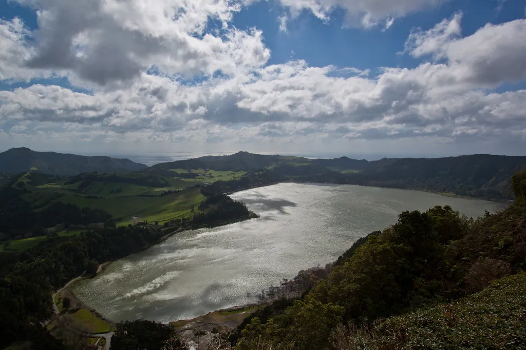
- Sete Cidades Twin Lakes Trail (São Miguel) — Walking the western crater rim delivers the iconic view of the blue and green twin lakes. The trail is free, rated easy, and runs about 8 km. Most hikers drop into the village at the bottom after 3–4 hours and taxi back up. Check the SpotAzores webcam for Vista do Rei before driving up — a wall of white on the screen means visibility at the lakes is zero.
- Lagoa do Fogo Shoreline Path (São Miguel) — The descent from the high ridge down to the protected lake inside a dormant volcano takes 2–3 hours. Access is free, but the parking lot at the top often requires a paid shuttle in July and August. Visit early morning to stay ahead of the clouds that typically settle by noon.
- Fajã dos Cubres to Santo Cristo (São Jorge) — This coastal route, officially PR01 SJO, connects two flat coastal plains formed by ancient landslides and lava flows. The path is free and takes 3.5–4 hours (9.5 km linear). The destination is a remote lagoon where clams are still harvested commercially. Many hikers stay overnight in Santo Cristo to experience the complete isolation of the northern coast.
- Caldeirão Crater Rim Walk (Corvo Island) — Corvo's central caldera is the island's only significant hiking destination, and it is unforgettable. The walk takes 2–3 hours, costs nothing, and winds through wildflower fields and grazing cattle. You will need a taxi from the village to the crater rim. Bring all supplies; there are no facilities after you leave the town of Vila Nova do Corvo.
- Criança Velha Vineyards Trail (Pico Island) — This flat 8 km route threads through the UNESCO World Heritage landscape of Pico's lower slopes. Black lava-rock walls enclosing bush vines stretch as far as you can see, with the volcano looming above. Three natural sea pools with changing facilities sit along the route, making this a rare combination of walking, swimming, and coastal scenery all in one morning.
- Monte Brasil Nature Reserve (Terceira Island) — Right beside Angra do Heroísmo, this extinct volcano features several interconnected forested loops taking 2–4 hours to explore. Entry is free. A sunset walk here puts golden light on the UNESCO city and its historic fortresses below. Keep an eye out for the wild deer that roam the upper slopes near the old WWII anti-aircraft batteries.
- Caldeira do Faial Perimeter Trail (Faial Island) — This 8 km loop follows the perfect circular rim of Faial's central volcano, which is filled with endemic vegetation. Free and well-maintained, the hike takes 3–4 hours and offers views of Pico and São Jorge on clear mornings. Wind on the ridge can be significant — carry a Little Donkey Andy Women's Waterproof Rain Jacket and keep it accessible, not buried at the bottom of your pack.
- Deserto Vermelho Red Desert Path (Santa Maria) — Santa Maria's ochre-colored clay soil creates a landscape unlike anything else in the archipelago. The walk is free, takes about two hours, and is best done in late afternoon when the sun deepens the red and orange hues. Bring significantly more water than you would carry on any other island — Santa Maria is measurably warmer and drier, and the trail offers almost no shade.
- Furna do Enxofre Volcanic Cave (Graciosa Island) — A hike down a spiral stone staircase into a massive lava dome with an underground lake and active sulfur fumaroles. Entry costs approximately €5; open 10:00–17:00 (hours vary by season). Check the CO2 monitor at the visitor center before descending — high gas concentrations occasionally close the lower gallery for safety.
Museums, Art, and Culture in Hiking
Hiking in the Azores is a walk through Atlantic history as much as volcanic geology. On Pico Island, the Criança Velha trail passes through a UNESCO World Heritage landscape where thousands of kilometres of hand-built black basalt walls shelter bush vines from salt spray and wind. These structures, called currais, were laid without mortar and have stood for centuries. Walking the trail during the late-summer harvest in August or September, when local families are out picking the Verdelho grapes, adds a layer of living agriculture to the scenery.
The Pico vineyards guide explains the full history of these walls and the wine cellars called adegas where Verdelho is still produced by hand. Several adegas along the coast are open to walkers and offer free tastings. It is the kind of incidental cultural encounter that guidebooks call authentic and that actually is.
On São Miguel, the Gorreana tea plantation trails offer a window into 19th-century agricultural history. Gorreana and the smaller Porto Formoso are the only industrial tea plantations in Europe. The Gorreana circular route (3.4 km, about one hour) is free and takes you into the heart of the fields, well away from the factory building. Visit on a weekday morning and you are likely to encounter the harvest crews with their strimmers — nothing is staged for tourists, it happens on its own schedule regardless of who is watching.
Parks, Gardens, and Outdoor Spots in Hiking
The Azores regional government manages an extensive network of protected natural reserves that form the backbone of the trail system. Faial's Caldeira Natural Reserve encompasses the volcanic crater and the surrounding laurisilva cloud forest — a type of ancient subtropical forest now restricted to the Azores, Madeira, and the Canary Islands. Up here the air is cool, damp, and completely still apart from shifting pockets of cloud that roll through the canopy every few minutes.
São Miguel's Sete Cidades caldera complex is a protected area worth exploring well beyond the main viewpoint. Most visitors park at Vista do Rei, take a photo, and leave. Walkers who continue along the rim path find hydrangea-lined paths, ocean views on one side, crater lakes on the other, and a quiet that the viewpoint never delivers. The Dez Vulcões trail on Faial connects the Caldeira rim with three separate volcanic cones across approximately 10 km — the full-length route is long and demanding, but a modified version blending three official trails captures the same volcanic topography in a more manageable half-day.
Flores Island remains the wildest and least-visited of the main islands, with hikes like PRC02 FLO Lajedo–Fajã Grande (8–10 km, 3–4 hours, moderate to hard) that pass through waterfalls and remote lava platforms virtually unseen by visitors focused on São Miguel or Pico. If your schedule allows even one additional island, Flores rewards serious hikers more than almost anywhere else in the archipelago.
Family-Friendly and Budget-Friendly Options in Hiking
The majority of official trails in the Azores are completely free. The regional government subsidises the trail maintenance system, so access to most routes — including all crater rim walks and coastal fajã paths — costs nothing beyond transport to the trailhead. Only a handful of sites charge any entry fee: Mount Pico summit registration (€5–€25) and Furna do Enxofre cave (approximately €5) are the main exceptions in 2026.
For families with children, the Gorreana tea plantation loop is ideal: flat, short (3.4 km), and ending with free tea samples at the factory. The Monte Brasil reserve on Terceira is also a reliable choice — the network of wide, forested paths means children can explore freely without exposure to steep drops or technical terrain. Both work well without any advance planning or booking.
Most Azores hiking trails are free — the regional government covers maintenance costs. Only Mount Pico summit registration (€5–€25) and Furna do Enxofre cave (approximately €5) charge an entry fee. Budget for taxi returns instead: linear trails typically cost €10–€25 to get back to your starting point.
Budget hikers should note that the main expense in the Azores is not trail access but logistics. Linear trails require a taxi return that typically costs €10–€25 depending on distance. Renting a car for €30–€50 per day and parking at both ends with a friend driving shuttle is the most cost-effective solution on larger islands like São Miguel. On smaller islands like Corvo, the single paved road makes getting around trivial, and the one significant hike (the Caldeirão crater) is free and accessible enough that only a short taxi lift to the rim is needed.
Stay Safe while Hiking in the Azores: what you need to know
Weather in the middle of the Atlantic is notoriously fickle and can shift from bright sunshine to heavy fog within minutes at altitude. The most important safety ritual is checking SpotAzores before driving to any trailhead — the site provides live webcam feeds of major viewpoints. If the camera at Vista do Rei shows a wall of white, it is almost always better to pivot to a coastal walk at sea level than to drive up and wait. WindGURU is the local tool for tracking wind speed and cloud ceilings at different altitudes. High winds on ridge trails like Faial's Caldeira can make balance on a narrow path genuinely dangerous. Check both tools together, not just a general forecast app.
Check the SpotAzores webcam and WindGURU together the evening before any caldeira hike — most crater trails cloud over by noon, so an early 07:00 start gives you the best chance of clear views at Sete Cidades, Lagoa do Fogo, or the Faial Caldeira.
Trail signage is unreliable in places. Red and yellow stripes mark the correct path; an X in those colors means wrong direction. If you lose the markers, backtrack to the last known sign rather than pushing through dense ferns. More practically, download Mapy.cz or Maps.Me before you leave the hotel. Both apps display contour lines and offline trail data. Every experienced hiker in the Azores uses one of these, not Google Maps, when the official markers disappear in the undergrowth.
Solo hikers face a specific risk: remote trails on São Jorge or Flores can go hours without another person passing. Before every hike, tell someone your exact planned route and the time you expect to finish. Give that person instructions to contact local authorities if they do not hear from you by a set hour. The official Azores trails website at trails.visitazores.com includes emergency contact numbers for each island on downloadable trail leaflets — save these contacts in your phone before you leave mobile coverage. This protocol costs nothing and eliminates the primary risk of hiking alone in the archipelago.
Essential Gear for Hiking in the Azores
Footwear is the single most important piece of kit. Volcanic basalt is slippery when wet, and caldeira floors and fajã descents are almost always muddy. Waterproof hiking boots with ankle support handle both conditions better than trail runners in most situations. Reliable options include the Merrell Women's Moab 2 Vent Hiking Shoe for drier trails and the Salomon Men's X Ultra Pioneer Mid Climasalomon Waterproof Hiking Boots for any route involving significant elevation change or known mud. Heavy leather boots are overkill — they become waterlogged and heavy on long descents and take days to dry in the humid climate.
Pack size matters less than pack function. For a standard day hike of 3–6 hours, a 20–22L pack with hip-belt load distribution is sufficient: the Osprey Tempest 20L Women's Hiking Backpack with Hipbelt distributes weight off the shoulders and keeps you stable on uneven terrain. If you are doing multi-day island hopping or carrying gear for an overnight at a remote fajã, step up to the Maelstrom Hiking Backpack 40L Waterproof Lightweight Daypack. A waterproof rain jacket is non-negotiable regardless of the forecast — a lightweight shell folds into the top pocket of any pack and takes seconds to pull on when the cloud drops.
One trade-off that confuses first-time visitors: trail runners versus waterproof boots. Trail runners drain faster and dry overnight; waterproof boots keep your feet dry for the first couple of hours but eventually saturate and stay wet for the rest of the day. On short trails under four hours in summer, trail runners with wool socks are the more comfortable option. On summit hikes, multi-hour linear routes with significant elevation, or any hike between October and April, waterproof boots are the correct choice.
São Miguel Island: The Sweet Smell of Nature
São Miguel is the entry point for most Azores visitors and the island with the most varied trail options. The contrast between the popular Sete Cidades caldera walk and the quieter Lagoa do Fogo shoreline path illustrates the island's range. Sete Cidades draws cruise-ship passengers and day-trippers to Vista do Rei; Lagoa do Fogo, twenty minutes east, receives a fraction of that traffic and delivers a more intimate volcanic lake experience with a sandy shoreline that feels genuinely remote.
The PRC37 SMI Rota da Água (7.6 km loop, 2–3 hours, easy to moderate) is an underrated option that passes through waterfalls and laurel forest in the interior and is rarely featured in mainstream guides. It makes a good second hiking day on the island when the main sights have already been covered. The Salto do Prego waterfall trail (PRC09 SMI, 4.5 km, 1.5–2 hours) ends at a 40-metre waterfall accessible only on foot and works well as a reliable backup when fog cancels higher-elevation plans.
The tea plantation trails at Gorreana and Porto Formoso remain two of the most distinctive short walks in the entire archipelago. Porto Formoso is smaller and quieter than Gorreana and has a terrace cafe where the ocean, the tea fields, and a bank of hydrangeas appear in the same view. It takes about 45 minutes and requires no planning at all. The São Miguel things to do guide breaks down how to time the island's main sights around the hiking windows to avoid cruise-ship crowds.
Corvo: A Traipse through Wildflower Fields
Corvo is the smallest and most remote inhabited island in the Azores, with a permanent population of around 400 people. Getting there requires a 90-minute ferry from Flores or a short flight, and flight frequency is limited — scheduling a visit requires planning weeks in advance in summer. The difficulty of arrival is exactly what keeps the island feeling untouched. Once there, the single significant hiking destination is the Caldeirão crater: a vast caldera several hundred metres deep, its interior carpeted with wildflowers and grazed by cattle that live year-round inside the volcano.
The PRC02 COR Caldeirão walk is about 6 km, takes 2–3 hours, and costs nothing. A taxi from Vila Nova do Corvo to the crater rim costs roughly €10–€15 and takes around ten minutes. Walk the rim in either direction and the caldera floor opens below — two small lakes sit at the centre, surrounded by seasonal wetland plants. The scale is disproportionate to the island's size; standing on the rim gives the feeling of looking into a landscape that has no connection to the tiny village below.
There are no facilities of any kind on the trail. Bring food, water, and everything you might need for 3–4 hours with no resupply option. The island receives enough fog to make a SpotAzores check important even here, though the Caldeirão rim tends to clear earlier in the day than the high-altitude trails on larger islands. Most visitors who make the journey to Corvo spend a full day on or around the crater and take the return ferry the following morning.
Graciosa: A Walk through the 'White Island'
Graciosa is called the White Island for its light-coloured volcanic rock and the whitewashed windmills that dot its low-lying landscape. It is one of the flatter islands in the archipelago, which makes its main hiking attraction — the Furna do Enxofre volcanic cave — all the more surprising. The cave is a massive lava tube that collapsed inward to form a dome roughly 50 metres high and 200 metres across. A subterranean lake sits at the base, and active sulfur fumaroles vent gas from fissures in the rock walls.
Entry costs approximately €5 and the site is open 10:00–17:00, with seasonal variation. The descent involves a long spiral stone staircase carved into the volcanic rock — the architecture alone justifies the visit. Check the CO2 monitor at the visitor centre before going down; gas concentrations occasionally exceed safe levels in the lower gallery after extended periods of low wind. The monitoring system is reliable and staff will not permit entry when readings are elevated.
Beyond the cave, Graciosa's gentle terrain and quiet roads make it one of the best cycling islands in the Azores if you want to combine wheels and walking. The island receives relatively low visitor numbers even in peak season, which means hiking trails here feel genuinely unhurried. Allow a full day for the island: the cave in the morning, followed by a coastal walk or a drive to the Pico Timão viewpoint in the afternoon.
Santa Maria: Wandering through the "Yellow Island"
Santa Maria is the oldest island in the Azores geologically, and the driest. Its landscape diverges sharply from the relentless green of São Miguel or Faial: the south coast features the Deserto Vermelho, a stretch of vibrant ochre and red clay soil more reminiscent of the Alentejo than the mid-Atlantic. Walking here in late afternoon, when the low sun deepens the pigment in the clay, is a genuinely different Azorean experience from anything available on the other eight islands.
The Deserto Vermelho trail is free, takes around two hours, and offers almost zero shade. Carry more water than you think you need — the heat on Santa Maria is measurably higher than on the central group islands, and the trail's exposed terrain accelerates dehydration. Santa Maria is also the only island in the Azores with limestone formations, which support different endemic plant communities than the volcanic basalt geology found elsewhere in the archipelago.
Santa Maria also offers Baía do São Lourenço, a white-sand beach accessible via a short coastal path — rare in the Azores, where most coastal access involves sea pools rather than sandy beaches. Combining the Deserto Vermelho walk in the morning with an afternoon at São Lourenço gives you a full and varied day that touches every distinctive feature the island has. Access from São Miguel via SATA flight takes around 30 minutes; the ferry is less frequent and significantly longer.
How to Plan a Smooth Hiking Attractions Day
Logistics are the hardest part of hiking in the Azores because many of the best routes are linear rather than circular loops. Save island-specific taxi numbers in your phone before you arrive — most drivers are accustomed to meeting hikers at remote trail ends, but they are not always reachable once you are mid-trail with patchy mobile coverage. On São Miguel, the main taxi dispatch services cover the island reliably. On São Jorge or Flores, ask your accommodation to recommend a driver the night before.
Timing matters more than effort level. Most caldeira trails cloud over by noon and are clearest in the late morning on good days. Start early — by 07:00 if you can — for the best chance of clear views at Sete Cidades, Lagoa do Fogo, or the Faial Caldeira. If you miss the window, shift to a coastal walk at sea level, where fog is less of an issue. The SpotAzores webcam check and a quick WindGURU reading the evening before give you enough information to set your alarm time with confidence. For detailed trail GPS logs and elevation profiles, Wikiloc has extensive user-recorded tracks from the Azores hiking community.
One practical tip that no webcam tells you: the Vista do Rei viewpoint at Sete Cidades is genuinely overwhelmed on cruise ship port days, which typically fall on Tuesdays and Thursdays in high season on São Miguel. The view is better — and completely quiet — from the hiking trail further along the rim. Walk twenty minutes past the abandoned hotel to reach spots that are never on a tour-bus itinerary.
Frequently Asked Questions
What is the best island for hiking in the Azores?
São Miguel offers the most variety for hikers, featuring everything from lake-filled craters to tea plantations. However, Pico is best for those seeking the challenge of a high-altitude summit climb.
Do I need a guide for hiking trails in the Azores?
Most trails are well-marked and safe for independent hikers using offline maps. A guide is only necessary for the Pico summit or for specialized canyoning and cave expeditions.
Are hiking trails in the Azores free to use?
The vast majority of trails are free and managed by the regional government. Only a few sites, like Mount Pico and Furna do Enxofre, require small conservation fees for access.
Hiking in the Azores is a deeply rewarding experience that connects you with the raw power of the Atlantic Ocean. By using tools like SpotAzores and WindGURU, planning for linear logistics, and choosing trails matched to the day's actual weather, you can navigate the islands with confidence. Respect the delicate ecosystems by staying on marked paths and carrying out all your rubbish.
For more detailed planning, check our Azores 7-day itinerary to see how to fit these hikes into your trip. The islands are waiting to be explored, one volcanic ridge and coastal fajã at a time.