
Capelinhos Volcano Faial: Complete Visitor Guide & History
Discover the lunar landscapes of Capelinhos Volcano on Faial. Plan your visit with tips on the Interpretation Center, hiking trails, and the 1957 eruption history.
On this page
Capelinhos Volcano Faial
Visiting the Capelinhos volcano Faial offers a rare glimpse into the raw power of nature. This barren, lunar landscape stands in stark contrast to the lush green hills found elsewhere in the Azores. It remains one of the most significant geological sites in the North Atlantic today. Travelers often include this site when planning their 14 Essential Tips and Things to Do in Faial Island Azores list for its historical depth.
The site marks the location of a massive underwater eruption that began in September 1957. For thirteen months, the earth spewed ash and lava, eventually creating new land on the island's western tip. Today, the area serves as a hauntingly beautiful reminder of the archipelago's volcanic origins. Understanding the history of this event helps visitors appreciate the resilience of the local community.
The Dramatic History of the Capelinhos Volcano Eruption
The eruption of 1957 changed the geography and social fabric of Faial forever. It began just off the coast near the Comprido lighthouse, surprising local fishermen with columns of water and ash. Over the next year, the volcano grew from the sea floor to join the main island, adding roughly 2.5 square kilometres of new land to Faial's western tip. This event buried the surrounding village and agricultural lands under meters of gray volcanic grit.
Many residents lost their homes and livelihoods as the ash destroyed crops and contaminated water supplies. In response, the United States passed the Azorean Refugee Act of 1958 to provide aid. This legislation was championed by then-Senator John F. Kennedy to help those displaced by the disaster. It allowed thousands of Faialense citizens to emigrate and build new lives in Massachusetts, Rhode Island, and California.
The cultural impact of this mass migration is still felt across the island today. Most families on Faial have relatives living on the US East Coast, and many villages here feel noticeably bilingual as a result. This strong connection to the diaspora adds a layer of human emotion to the desolate landscape. Visitors can see the remains of houses partially buried by the relentless fall of volcanic sand, a silent memorial to what was lost.
Exploring the Capelinhos Volcano Interpretation Center
The Capelinhos Volcano Interpretation Center is a masterpiece of modern architecture hidden beneath the volcanic ash. Designers built the museum underground to avoid disturbing the protected landscape of the cape. This innovative approach preserves the visual integrity of the lighthouse and the surrounding slopes. Walking down the concrete ramps into the earth feels like entering a high-tech bunker.
Inside, the museum offers a world-class education on the science of plate tectonics and volcanic activity. Detailed models show how the 1957 eruption progressed through its various phases over thirteen months. Interactive screens allow visitors to track seismic activity across the entire Azores archipelago in real time. The center also houses an impressive collection of rocks and minerals, and an exhibition dedicated to the architectural diversity of Azorean lighthouses.
The museum was nominated by the European Museum Forum as a finalist for "Best Museum in Europe" in 2012 — a remarkable recognition for a small island institution. One of the most moving sections focuses on the personal stories of survivors: historical photographs, newsreels, and artifacts recovered from the buried villages. These exhibits provide a sobering look at the challenges faced by the local population. Plan to spend at least two hours here to fully absorb the scientific and human content. You can check current details at the Capelinhos Volcano Interpretation Center official site.
Know Before You Go: Museum Hours, Tickets, and Practicalities
The Interpretation Center is open daily from 10:00 to 18:00 between April and October. In the off-season (November through March) it closes on Mondays and shuts at 17:00 on the remaining days. Last admission is 30 minutes before closing. Adult tickets run approximately €8; children and seniors qualify for a reduced rate of around €4. The lighthouse climb is included in the ticket price.
A few practical notes that first-time visitors frequently overlook. The site has no petrol station nearby, so fill your tank in Horta before heading west. The small café inside the center is the only food option at the cape itself, so bring snacks if you plan to hike or spend a full morning outdoors. The car park accommodates coaches and gets busy between 11:00 and 14:00 from June through August — arriving before 10:00 or after 15:30 avoids the main crowd.
Fog is the most common disruption at the cape, not rain. When low cloud rolls in off the Atlantic it can reduce visibility to near zero within minutes, completely obscuring the lighthouse. Before driving out from Horta, check the regional weather forecast for "Capelo" specifically, as the western tip of the island sits in a distinct microclimate and can be socked in even when central Faial is clear and sunny. If you arrive to thick fog, the Interpretation Center underground is still fully worth visiting — the outdoor landscape can wait for an afternoon window.
The cape sits in its own microclimate — fog can roll in off the Atlantic within minutes and completely obscure the lighthouse, even when central Faial is clear. Check the weather forecast for "Capelo" specifically before making the 30-minute drive from Horta.
How to Reach Capelinhos and Ways to Explore the Site
Reaching the volcano is straightforward if you are staying in the main town of Horta. The drive takes approximately 25 to 30 minutes along the scenic EN1 coastal road, passing through the village of Capelo. Many visitors stop at the Horta Marina Faial Azores: The Ultimate Guide for Travelers before heading west to top up on coffee and get fuel. Parking is free and plentiful near the entrance to the Interpretation Center.
There are three distinct ways to see the volcano, each suited to a different pace and fitness level.
- By car: the fastest option. Drive directly to the Interpretation Center car park. Combine with a short self-guided walk across the ash fields to the lighthouse. Suitable for all ages and those with limited time; add roughly two hours on top of the museum visit.
- On foot via the 10 Volcanoes Trail: a 19 km full-day hike from the Caldeira rim down to the coast. Spectacular but demanding — allow 6 to 8 hours and arrange a return taxi from the cape. Check the Official 10 Volcanoes Trail map before you go.
- By guided boat tour: several operators out of Horta offer coastal tours that bring you face-to-face with the sea cliffs formed by the 1957 lava flows. This perspective is not visible from land and shows just how dramatically the eruption reshaped the coastline. Best in calm summer weather; book in advance during peak season.
Weather conditions at the cape can be significantly different from the rest of the island. Strong winds are common, so wearing a windproof jacket is highly recommended even in summer. If you visit in 2026, arriving early in the morning beats the tour buses. The museum can get crowded during the peak hours of 11:00 to 15:00. Consult a guide on the 10 Essential Tips for the Best Time to Visit the Azores to plan the wider trip.
Hiking the 10 Volcanoes Trail to the Coast
For active travelers, the 10 Volcanoes Trail is the ultimate way to reach Capelinhos. This 19-kilometre long-distance path starts at the island's highest point and descends through a chain of volcanic cones to the western coast. It offers sweeping views of both the north and south coastlines of Faial simultaneously. The route passes through diverse microclimates, from misty laurel forest to the arid ash fields of the cape. For more details on hiking and outdoor activities across all Azores islands, consult the Visit Azores official tourism website.
Hikers will encounter several notable peaks along the way. Cabeço Verde is accessible by car and provides orientation views over the whole western peninsula. Cabeço do Canto, reached only on foot at 346 metres, passes the entrance to Furna Ruim — a volcanic cave roughly 55 metres deep listed within the Natura 2000 network of protected areas. These ancient craters provide a fascinating comparison to the relatively young Capelinhos site. The final descent onto the ash fields reveals the sheer scale of the 1957 lava flows before the lighthouse comes into view.
One section of the trail that many guides overlook is the short detour following the Interpretive Circuit called the Whalers' Paths. This marked route around the cape takes you through the ghost of the old whaling village that was buried during the eruption. Stone walls, terrace outlines, and the bases of former houses are still partially visible beneath the ash — a grounding reminder that this landscape was once farmland. The detour adds only 30 to 45 minutes and is included in the self-guided circuit near the Interpretation Center.
- Segment 1: The Highland Start
- Start: Caldeira Rim
- End: Cabeço dos Trinta
- Difficulty: Moderate
- Highlight: Cloud forest views; crater tunnel entrance at Cabeço dos Trinta
- Segment 2: The Volcanic Ridge
- Start: Cabeço dos Trinta
- End: Cabeço do Canto
- Difficulty: High
- Highlight: Exposed crater walking, Furna Ruim cave
- Segment 3: The Ash Descent
- Start: Cabeço do Canto
- End: Capelinhos Lighthouse
- Difficulty: Moderate
- Highlight: Lunar landscape transition, Whalers' Paths circuit
Be prepared for steep sections and loose volcanic gravel that becomes slippery when wet. Most hikers arrange for a taxi or shuttle to return to Horta after finishing the trek rather than retracing their steps.
The 10 Volcanoes Trail is 19 km one-way with no return route — book a taxi or shuttle from Capelinhos back to Horta before you set off. The trail passes through the Furna Ruim volcanic cave area (a Natura 2000 protected site) and takes 6 to 8 hours for most hikers.
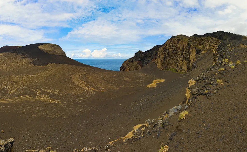
The Iconic Capelinhos Lighthouse and Lunar Landscape
The Capelinhos Lighthouse stands as a silent witness to the destructive power of the earth. Once a functioning beacon for sailors, it now marks the boundary where the old island meets the new land added by the eruption. Visitors can climb the stone steps of the tower for a panoramic view of the ash fields and the Atlantic. From the top, the contrast between the deep blue ocean and the gray volcanic sand is one of the most arresting sights in the entire archipelago.
Photography enthusiasts will find endless inspiration in the stark geometry of the landscape. The best time for capturing the lighthouse is during the golden hour just before sunset, when low light rakes across the undulating dunes of volcanic ash and throws long shadows across every ridge and furrow. Midday shots work surprisingly well too on overcast days, when the diffuse light removes glare and emphasises the monochrome texture of the ash field. The ruined walls of the buried village make for strong foreground subjects when the lighthouse is positioned in the background.
Walking across the ash fields feels like stepping onto another planet. There is very little vegetation here, as the soil is still relatively young and nutrient-poor. The silence of the area is often broken only by the wind and the crashing waves. This unique environment makes Capelinhos one of the most photographed locations in the Azores, yet it rarely feels crowded before 10:00 or after 16:00.
Beyond Capelinhos: Faial's Central Caldeira and Volcanic Peaks
While the volcano is a major draw, the rest of Faial offers equally impressive volcanic features. The central Caldeira is a massive crater measuring 2,000 metres in diameter and 400 metres deep, formed more than 10,000 years ago. Its last eruption, roughly 1,000 years ago, covered 75 percent of the island with pumice. Today the crater floor is filled with lush, dense laurel forest — a World Heritage-quality patch of native woodland — and provides a striking visual contrast to the barren ash fields of the west coast.
You can visit the Caldeira rim by car in about 20 to 30 minutes from Horta. The circular 8-kilometre perimeter trail is accessible to walkers of varying fitness levels and offers panoramic views of both the island's coastline and the neighboring island of Pico on clear days. Descending into the crater interior requires a certified guide and advance booking, as daily visitor numbers are capped to protect the ecosystem. At 1,043 metres above sea level, Cabeço Gordo is the island's highest accessible point and delivers a four-island panorama on cloudless mornings.
Many travelers combine a visit to Faial with a trip to see 14 Best Things to Do on Pico Island, Azores. The short ferry ride between the islands makes it easy to explore multiple volcanic landscapes in one trip. This is a popular route for those following an Island Hopping Azores Guide: Routes, Ferries & Flights itinerary. Taken together, the Caldeira and Capelinhos represent the full arc of Faial's volcanic story — ancient stability versus violent, recent change.
Frequently Asked Questions
Is Capelinhos Volcano still active?
The Capelinhos volcano Faial is currently considered dormant rather than extinct. While the main eruption ended in 1958, scientists continue to monitor the area for seismic activity and gas emissions. It is perfectly safe for tourists to visit the site and the museum today. Check the Faial guide for more safety tips.
How do you get to Capelinhos from Horta?
The easiest way to reach the site is by renting a car and driving west for about 30 minutes. You can also take a taxi or join a guided tour from the Horta Marina. Public buses are available but run on a limited schedule that may not suit all travelers.
Can you climb the Capelinhos lighthouse?
Yes, visitors can climb the lighthouse tower for a small fee during the museum's operating hours. The view from the top provides a unique perspective of the 1957 lava flows and the new coastline. Be aware that the stairs are steep and may not be suitable for everyone.
What is the 10 Volcanoes Trail?
The 10 Volcanoes Trail is a 19-kilometer hiking route that spans the volcanic ridge of Faial. It connects the central Caldeira to the Capelinhos site on the western coast. The trail offers some of the most dramatic volcanic scenery in the entire Azores archipelago.
How much time do you need at the Capelinhos Interpretation Center?
Most visitors find that two to three hours is sufficient to explore the museum and the lighthouse. This allows enough time to watch the documentary films and read the scientific displays. If you plan to hike the local trails, you should budget for a full day.
The Capelinhos volcano Faial stands as a testament to the ever-changing nature of the Azores. From its violent birth in the 1950s to its current status as a protected monument, it remains a must-see destination. Visitors leave with a profound appreciation for the geological forces that shape our planet. Whether you are a hiker or a history buff, this site offers an unforgettable experience.
Use our Azores tourist attractions hub to plan the rest of your trip.