How Big is Madeira? (6 Key Facts on Size and Scale)
Discover the exact size of Madeira island, including total area in km2, dimensions, and how it compares to other famous islands for your travel planning.
On this page
How Big is Madeira? (6 Key Facts on Size and Scale)
Madeira covers 796 square kilometers (307 square miles) in total land area — that figure includes the main island and its smaller surrounding islets. The main island itself measures 741 km2, making it the largest landmass in the Madeira archipelago. This volcanic territory sits in the Atlantic Ocean roughly 978 km southwest of mainland Portugal. Understanding the island's true size helps you plan realistic driving routes, pick the right base, and set accurate expectations for how much you can cover each day.
Total Land Area and Physical Dimensions
The main island stretches approximately 57 kilometers (35 miles) from east to west at its longest point. Its maximum width is about 22 kilometers (13.6 miles) north to south, giving it a distinctly elongated shape. The coastline runs roughly 150 kilometers in total, a surprisingly long perimeter for an island this size — a result of the deeply indented volcanic cliffs and bays that break up the shoreline.

Surface area of 741 km2 for the main island places it firmly in the "small island" category by global standards, yet the terrain means the usable and navigable land feels considerably larger. You can explore more about the island's geographical context in our Where Is Madeira: Location, Geography, and Travel Guide guide. The volcanic origin has left an uneven, crumpled landscape of ridges and deep valleys rather than the flat interior you might find on a coral or sedimentary island of equivalent area.
Elevation is the key number that most size-focused articles omit. The island rises from sea level to 1,862 meters at Pico Ruivo in a horizontal distance of only a few kilometers. That vertical range — equivalent to the height of the French Alps' lower peaks — adds a third dimension to the island's effective scale. For your 2026 trip, keep this in mind: two points that are 10 km apart on a map can involve 1,200 meters of ascent and descent between them.
Madeira Size Comparisons: Putting 796 km2 into Perspective
Raw numbers mean little without context. Madeira's main island at 741 km2 is roughly 1.5 times the size of the Isle of Wight, which covers about 380 km2. For US visitors, the island is close in area to New York City's five boroughs combined. For mainland European visitors, it is comparable to Hamburg's city limits or roughly half the size of Luxembourg.
Comparing it to other Atlantic and Mediterranean island destinations puts the scale in sharper relief. The Canary Islands, another Atlantic archipelago, are roughly three times larger than Madeira — yet Madeira's vertical terrain compresses its effective navigable area significantly. The table below uses the main island figures where available.
| Island | Area (km2) | Length (km) | vs. Madeira |
|---|---|---|---|
| Madeira (main) | 741 | 57 | — |
| Tenerife | 2,034 | 96 | 2.7× larger |
| Gran Canaria | 1,560 | 56 | 2.1× larger |
| Ibiza | 572 | 41 | 23% smaller |
| Isle of Wight | 380 | 37 | 49% smaller |
| Porto Santo | 42 | 11 | 94% smaller |
The comparison with Tenerife is instructive for travelers weighing both destinations. Tenerife is nearly three times larger in land area, but Madeira's vertical terrain compresses distances in a way that makes a week feel well-filled. You can see how this compact-but-complex geography affects costs in our Is Madeira Expensive? 9 Things to Know About Costs analysis. Ibiza, by contrast, is flatter and almost entirely traversable by car in under an hour — Madeira demands more time despite being only 30% larger.
How Long Does it Take to Drive Across Madeira?
Driving from the eastern tip at Caniçal to the western end at Porto Moniz takes roughly 90 minutes on the Via Rapida expressway. That east-to-west corridor covers the island's full 57 km length. Before the tunnel network was completed in the early 2000s, the same trip on the old coastal road took three hours or more. Today the journey is fast — until you leave the expressway.
Madeira has more than 29 tunnels totalling over 55 km, which means a significant portion of any cross-island drive passes underground. This engineering was the only practical solution given the terrain: blasting through ridges is faster than switchbacking over them. The tunnels cut journey times dramatically, but they also mean you can miss entire valleys if you stick to the main routes. Planning a Madeira Itinerary 5 Days Travel Guide gives you enough time to use both the fast tunnels and the scenic old roads.
Crossing north to south is the shorter axis: only about 22 kilometers, but the road climbs to over 1,200 meters before descending. Allow 40 to 50 minutes in good conditions; add another 20 to 30 minutes if you encounter fog on the central plateau, which is common in the morning. The north-to-south trip is one of the most dramatic short drives in Europe, passing through the Encumeada pass with views to both coasts on a clear day.
Renting a car remains the most practical way to navigate these dimensions. Public buses reach most villages but schedules are infrequent on mountain routes, and the journey times are two to three times longer than by car. Plan for scenic viewpoint stops — there are dozens, and each one adds 15 to 20 minutes to any route.
The north-to-south crossing via the Encumeada pass climbs above 1,200 metres and frequently has morning fog — allow an extra 20 to 30 minutes and check conditions before you set off. The drive offers views to both coasts on a clear day.
Geography and Topography: Why the Island Feels Larger
Pico Ruivo at 1,862 meters is the highest point, but the dramatic relief starts much lower than that. The island's central spine runs east to west and rises steeply from both the north and south coasts, creating a landscape where sea cliffs give way to alpine vegetation within a few kilometers. This vertical compression is the main reason first-time visitors consistently underestimate how long it takes to move between points.
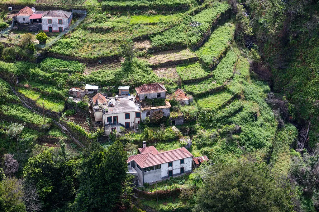
Deep valleys — locally called "ribeiras" — cut down from the central ridge to the sea and force roads into long detours. A village visible on the opposite wall of a ribeira might be 20 minutes away by road even though it looks like a five-minute walk. This geographic complexity makes Madeira feel, in practice, much larger than 741 km2. The same rugged terrain preserves the Laurissilva forest, a UNESCO World Heritage Site that covers roughly 20% of the island's interior and limits where roads can be constructed.
Weather adds another layer of perceived scale. The island can be simultaneously sunny on the south coast in Funchal, raining on the north coast near São Vicente, and foggy at altitude in the same afternoon. Moving between these climate zones takes planning and time, reinforcing the sense that the island stretches farther than a map suggests. This is the Madeira Travel Guide: The Ultimate Island Planning Resource reality that raw km2 figures can never convey.
Size of the Madeira Archipelago (Porto Santo and Desertas)
The entire Madeira archipelago covers 801 square kilometers across four island groups: the main island, Porto Santo, the Desertas, and the Selvagens. Porto Santo is the only other inhabited island, measuring about 42 km2 with a maximum length of 11 kilometers. It sits roughly 43 kilometers northeast of Funchal and is reached by a two-hour ferry or a 20-minute flight.
The Desertas Islands — Deserta Grande, Bugio, and Ilhéu Chão — add only a few square kilometers to the total but carry ecological significance out of proportion to their size. They host one of the last surviving populations of the Mediterranean monk seal in the eastern Atlantic, along with globally important seabird colonies. Access is strictly controlled and requires a permit from the Madeira Natural Park authority.
According to visitmadeira.com, the archipelago's autonomous political status as a region of Portugal reflects both its geographical separation and its distinct character. The Selvagens, a tiny group of rocks 280 km south of Madeira, are the southernmost Portuguese territory and are uninhabited. If you are planning to visit Porto Santo, it is worth reading our Is Madeira Portugal Safe? 10 Essential Safety Tips for Travelers guide for general safety and logistics context across the archipelago.
Porto Santo is a fundamentally different landscape from the main island: flat, dry, and backed by a nine-kilometer golden sand beach rather than volcanic cliffs. Visiting both islands in one trip reveals the full range of the archipelago's geography and adds only a short detour to your overall itinerary.
Porto Santo sits roughly 43 kilometres northeast of Funchal and is reachable by a two-hour ferry or a 20-minute flight — a manageable day trip or overnight add-on from the main island.
Planning Your Madeira Trip: Logistics and Activities
Madeira's compact size works strongly in a traveler's favor. Because the island is only 57 km long, you can use a single base — most visitors choose Funchal — and reach any corner of the island as a day trip. From the center of Funchal, the western villages of Porto Moniz and Seixal are under 90 minutes away, and the eastern Ponta de São Lourenço peninsula is about 45 minutes. This eliminates the need to change hotels mid-trip, which reduces cost and logistics.
The island's climate and location in the Atlantic at 32°N latitude mean it stays mild year-round: Funchal averages 16°C in January and 24°C in August. The north coast runs cooler and wetter; the south coast where most tourist infrastructure sits is sunnier. This north-south split is the practical climate reality travelers need to understand, and it affects packing as much as any seasonal variation does.
Because of the moderate distances involved, Madeira suits walkers as much as drivers. The levada network — over 2,100 km of irrigation channels converted into walking trails — covers the entire island at various altitudes. Many levada walks are point-to-point rather than circular, which means a car or bus transfer at one end. The island's scale makes these logistics manageable without needing a guide or tour. Consider staying at 10 Best Madeira Hostels and Planning Tips if you plan to use the levadas heavily and want to connect with other hikers who can share transport.
For most 2026 visitors, four to five days is the minimum to cover the island's distinct zones: the south coast and Funchal, the north coast, the central highlands, and the eastern peninsula. Seven to ten days allows you to add Porto Santo and the interior levada walks at a more relaxed pace. The island's 796 km2 reward patience — rushing it means missing the microclimates, viewpoints, and village culture that no map scale can convey.
Frequently Asked Questions
How many miles long is Madeira?
Madeira island is approximately 35 miles (57 kilometers) long at its greatest extent. It has a maximum width of about 13 miles (22 kilometers). These dimensions make it easy to traverse the entire length of the island in under two hours using the modern tunnel system. Check our latest blog posts for more travel tips.
Can you drive around Madeira in one day?
Yes, you can drive around the perimeter of Madeira in a single day. However, this pace leaves very little time for hiking or exploring the local villages. Most travelers prefer to split the island into regions and spend at least three to five days exploring properly.
Is Madeira bigger than the Isle of Wight?
Madeira is significantly larger than the Isle of Wight, measuring roughly 1.5 times its size. While the Isle of Wight is about 380 square kilometers, Madeira's main island is 741 square kilometers. The dramatic mountains in Madeira also make it feel much larger than its flat counterparts.
How many square kilometers is Madeira?
The total land area of the Madeira archipelago is 801 square kilometers. The main island itself accounts for 741 square kilometers of that total. This compact size allows travelers to see a wide variety of landscapes without spending long hours in transit between destinations.
Madeira offers a unique blend of compact size and massive geographical diversity.
Understanding the physical scale of the island helps you create a more efficient and enjoyable travel itinerary.
Whether you are hiking the high peaks or driving the coastal roads, the island's 796 square kilometers provide endless exploration.
For the wider island context, see our complete guide to things to do in Madeira.