Praia Da Luz From Lagos: Complete Hiking & Transport Guide
Plan your trip from Lagos to Praia da Luz with our guide to the Fishermen's Trail. Includes maps, bus schedules, hiking times, and expert local tips.
On this page
How to Travel to Praia Da Luz From Lagos: A Complete Guide
Quick answer: walking the Fishermen's Trail from Lagos to Praia da Luz covers 12.1 km in about 3 to 4 hours and is the most rewarding option in 2026. If you do not want to hike, the Onda Bus Linha 4 costs €1.60 / ~$1.75 and reaches Luz in roughly 20 minutes, while an Uber takes 15 minutes for €7–€10 / ~$8–$11.
I have walked the coastal path between Lagos and Luz in both directions across multiple seasons. The route is a southern bookend of the Rota Vicentina and links some of the most photographed cliffs in southern Portugal: Ponta da Piedade, Dona Ana, Camilo, and Porto de Mós. Many visitors rate this stretch as the highlight of their things to do in Lagos.
This guide covers the exact distances between landmarks, the new boardwalks that changed the route in 2024, transport alternatives with prices, wind and tide strategy, and where to begin in Luz if you are walking the trail in reverse. Use it to decide whether to hike, half-hike, or skip the cliffs entirely and ride the bus.
Lagos to Praia da Luz Route Overview
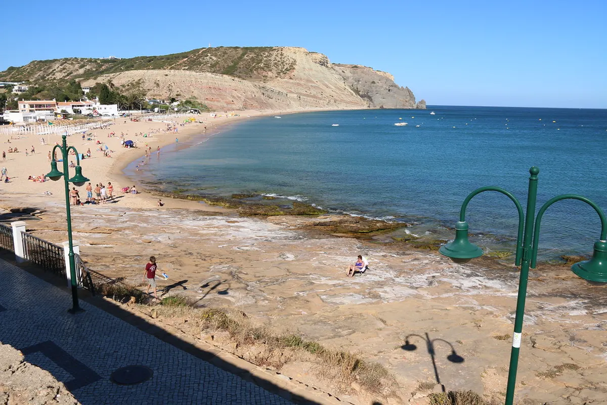
The full coastal route is 12.1 km from Lagos Train Station to the beach in Praia da Luz, with about 274 m of total ascent. The path moves through four distinct zones: the urban Lagos waterfront, the Dona Ana–Ponta da Piedade boardwalks, the Porto de Mós valley, and the open clifftop run into Luz. Most walkers finish in 3 to 4 hours; brisk hikers can do it in 2.5.
The most popular plan is to walk one way and ride back. Hike out from Lagos in the morning when the cliffs are shaded, cool off at Luz beach, then take the Onda bus or an Uber back. If you only want a taste of the trail, end at Porto de Mós (km 7.35) where Bus 4 also stops and where two beachfront restaurants offer lunch.
Public transport works year-round and is the fallback if the heat, the wind, or sore feet end the hike early. Uber and Bolt operate reliably in Lagos and at Porto de Mós, but coverage thins between km 8 and km 11 along the cliffs, so plan an exit point before you commit to that section.
Interactive Map & GPX File for the Trail
The trail is signposted, but a downloaded GPX track removes any doubt at the two confusing junctions: the left turn near the Lagos fire station (km 2.0) and the residential block between the Ponta da Piedade boardwalks and Porto de Mós beach (km 6.35–7.35). Load the file into Gaia GPS, Komoot, or your watch before leaving Wi-Fi at the marina.
If you do not want to wrangle a GPX file, screenshot the offline map in Google Maps with these eight waypoints saved: Lagos Train Station, Lagos Marina footbridge, Praia Dona Ana, Praia do Camilo stairs, Ponta da Piedade lighthouse café, Porto de Mós beach, the white beacon at km 10.8, and Bar Habana on Avenida dos Pescadores in Luz. That covers every navigation decision on the route.
Cell coverage is strong on Vodafone and MEO across the entire trail in 2026, so live tracking works as a backup. The "escape routes" that drop inland to the N125 road are clearly marked with the same blue stripes used on the main path; use them if weather turns or daylight is running out.
Trail Distance & Difficulty by Landmark
Distances matter on this hike because each segment has a very different character. The first 6.35 km from Lagos Train Station to the end of the new boardwalks is essentially flat, paved, and stroller-feasible. The middle kilometer through Porto de Mós is residential pavement. The last 4.75 km from Porto de Mós to Luz is the actual cliff hike, with two short climbs and a steep descent.
- Lagos Train Station to Praia Dona Ana boardwalk start: 2.15 km, flat with one small hill at the fire station turn.
- Praia Dona Ana to Ponta da Piedade lighthouse: 2.5 km on the 2024 boardwalks, including the Camilo Beach stairs detour.
- Ponta da Piedade to Porto de Mós beach: 1.7 km, mostly downhill on residential streets.
- Porto de Mós to white beacon (km 10.8): 3.45 km, the main clifftop section with the steepest climb.
- White beacon to Praia da Luz beach: 1.3 km descent into Luz village.
The hike is rated easy-moderate overall. The Ponta da Piedade boardwalks, completed in 2024, removed what used to be the toughest navigation on the route, and families with older children now finish the full distance comfortably. The genuine difficulty is concentrated in the cliff climb out of Porto de Mós and the loose-gravel descent into Luz, both of which require sturdy shoes.
How the 2024 Boardwalks Changed the Hike
Most online guides still describe a dirt-track scramble between Dona Ana and Ponta da Piedade. That route no longer exists. In 2024, the Lagos municipality opened a continuous 4 km wooden boardwalk from Praia Dona Ana to the lighthouse, and it has reshaped how the first half of this hike actually works.
The practical implications: the front 6.35 km is now wheelchair-friendly with assistance and stroller-passable for off-road models, viewpoints have railings (so vertigo-prone walkers can finally enjoy the cliffs), and the surface stays usable even in light rain when the old dirt path turned to mud. Sunset photographers benefit too: the boardwalks offer fixed vantages over Camilo and Dona Ana at golden hour without scrambling.
The flip side is foot traffic. The boardwalks are now busy from 10:00 to 17:00 in summer, especially the Camilo Beach overlook. If you want the cliff-edge solitude that older guides promised, walk this section before 09:00 or save it for a March or November visit.
The Fishermen's Trail in Context
The Lagos–Luz section is the southernmost stage of the Fishermen's Trail, a 230 km coastal route that runs north from here to São Torpes Beach in Alentejo. It is part of the wider Rota Vicentina network, originally cleared so local fishermen could reach cliff-top access points to the sea. The full trail takes 11–13 days to walk; this single stage is the easiest, most photogenic taster.
What makes the Lagos–Luz section different from the Alentejo stages further north is the geology. North of Sagres the trail follows shale and schist cliffs over Atlantic surf beaches. Around Lagos, the rock turns to soft golden limestone, sculpted by the sea into the arches, stacks, and sea caves that define Ponta da Piedade. You see more swimming-friendly coves and warmer water on this stage than anywhere else on the Rota Vicentina.
The route is administered by the Rota Vicentina nonprofit, which maintains the markers and publishes free maps at rotavicentina.com. Their signposts at Lagos Marina and Bar Habana in Luz mark the official termini of the trail.
Where the Trail Starts and Finishes
The official Lagos trailhead is the signboard outside Lagos Train Station, immediately behind the Marina. From the station, cross the pedestrian bridge over the marina, follow Avenida dos Descobrimentos along the waterfront with the river on your right, then bear left near the fire station (Bombeiros) at the 2 km mark. From there the green-and-blue stripes guide you to the start of the boardwalk at Praia Dona Ana.
In Praia da Luz, the trail finishes (or starts, in reverse) on Avenida dos Pescadores, the seafront promenade. The exact landmark is Bar Habana, a beachfront café with live music in summer; the Rota Vicentina signboard is a few meters east of it, against the low wall facing the black volcanic outcrop of Ponta Negra. If you are walking from Luz to Lagos, this is your starting point.
If your Lagos accommodation is in the Old Town or Marina, you can also pick up the trail at Praia Dona Ana itself and skip the urban first 2.15 km. That shortcut saves about 30 minutes but means missing the historic waterfront.
Can the Trail Be Walked Both Ways?
Yes, the trail is fully bi-directional and the green-and-blue stripes are painted on both sides of every marker. Most local hikers actually prefer the Luz-to-Lagos direction because it ends with a meal in town and avoids the steep, slippery descent into Luz at the end of a tired afternoon.
Wind direction is the underrated factor. The "Nortada" northwest wind kicks in most summer afternoons, often blowing 25–35 km/h between 14:00 and 18:00. Walking westward toward Luz puts the wind in your face and can feel exhausting on the open cliff section. Walking eastward toward Lagos has the wind at your back. If the morning forecast shows Nortada above 25 km/h, take the bus to Luz and walk back.
Sun angle is the second factor. From October to March, the sun sits low and southern. Walking westward in the afternoon means it is in your eyes for the entire cliff section and washes out photographs. Reverse the direction in winter and you get warm side-light on the cliffs the whole way.
Route Markers & Navigation Tips
The Fishermen's Trail uses two short horizontal stripes, one green over one blue, painted on rocks, posts, walls, and even trash bins. Two parallel stripes mean you are on the route. Two stripes forming an "X" mean you are heading away from it; turn around. A single stripe with an arrow indicates a direction change at a junction.
The markers are dense in the Lagos urban section and on the boardwalks but thin out on the open cliffs between Porto de Mós and the white beacon. If you have not seen a stripe in 10 minutes on that stretch, stop and check your GPS rather than continuing. Faded paint is most common on the seaward side of marker rocks where salt spray hits.
The single biggest navigation mistake people make is taking unmarked shortcuts down the cliffs near Luz. The official path switchbacks for a reason: the direct lines are crumbling sandstone and have caused multiple injuries in recent seasons. Stick to the painted route even when you can see the beach below.
How to Get to Praia da Luz: Bus, Uber, or Walking
Three transport options connect Lagos and Praia da Luz year-round. Each has trade-offs in time, cost, and view quality. The table below summarizes them so you can pick before leaving the hotel.
- Onda Bus Linha 4: €1.60 / ~$1.75, 20 minutes, departs every 30–60 minutes from Lagos bus terminal, last bus around 19:30 in summer and 18:30 in winter.
- Uber or Bolt: €7–€10 / ~$8–$11, 15 minutes, 24/7 availability, app-based payment, fastest option for luggage.
- Licensed taxi from Lagos rank: €10–€14 / ~$11–$15, 15 minutes, cash or card, useful when surge pricing hits the apps.
- Walking the Fishermen's Trail: €0, 3–4 hours, requires daylight and decent fitness, gives you the actual reason to come.
The Onda Bus is part of the wider Algarve public transport network. Buy tickets directly from the driver in cash or with a contactless card. The Lagos terminal is a 5-minute walk from the train station, and the Luz stop is on Rua Direita, two blocks back from the beach.
If you are arriving in the Algarve from abroad, the easiest connection is to fly into Faro Airport and take the regional CP train to Lagos. Trains run roughly every 90 minutes, the journey takes 1 hour 40 minutes, and the fare is €8.30 / ~$9. From Lagos station you are 50 meters from the trailhead, which is the smoothest airport-to-trail transition in Portugal.
| Option | Cost | Journey Time | Frequency | Best For |
|---|---|---|---|---|
| Onda Bus Linha 4 | €1.60 / ~$1.75 | ~20 min | Every 30–60 min | Budget travel, no luggage |
| Uber / Bolt | €7–€10 / ~$8–$11 | ~15 min | On demand, 24/7 | Convenience, small bags |
| Licensed taxi | €10–€14 / ~$11–$15 | ~15 min | Rank at Lagos center | When apps have surge pricing |
| Walk (Fishermen's Trail) | Free | 3–4 hours | Any time with daylight | Scenery seekers, hikers |
The Onda Bus Linha 4 last departure from Praia da Luz back to Lagos is around 19:30 in summer and 18:30 in winter. Buy your return ticket directly from the driver with cash or contactless card.
Best Time of Year and Day to Walk
The cliff section between Porto de Mós and Luz has zero shade, and the limestone reflects sun back at you. From late June through August, midday surface temperatures on the open path can hit 38°C even when the air reads 30°C. Plan to be off the cliffs by 11:30 in summer or wait until after 17:00 when the sun drops behind the inland hills.
April, May, October, and early November are the sweet spots: temperatures of 18–24°C, low rainfall, wildflowers on the cliff tops in spring, and the boardwalks blissfully empty. Winter (December to February) is walkable and often beautiful, but check the forecast for rain because the Porto de Mós to Luz climb gets slippery and the descent to Luz turns into mud.
For families and slower walkers, the half-route option to Porto de Mós is the smart choice in any season. You get the entire boardwalk experience, the Camilo Beach stairs, and Ponta da Piedade, then end at a beachfront restaurant where Bus 4 stops every hour. Total walking distance is 7.35 km and the elevation gain disappears.
April, May, October, and early November offer the best hiking conditions: temperatures of 18–24°C, low rainfall, and far fewer crowds on the boardwalks. Avoid the open cliff section between Porto de Mós and Luz after 11:30 in summer — surface temperatures can reach 38°C with no shade.
What to Pack for the Coastal Hike
The packing list is short but non-negotiable. There are no water sources between Porto de Mós (km 7.35) and Luz beach (km 12.1), and the Atlantic sun and wind are stronger than the temperature suggests. You can pick up a Fishermen's Trail T-shirt as a souvenir but the gear below matters more.
- At least 1.5 liters of water per person, 2 liters in summer.
- SPF 30+ sunscreen reapplied every two hours, plus a wide-brimmed hat.
- Sunglasses with side coverage to handle the limestone glare.
- Trail runners or light hiking boots with grippy soles for the gravel descent into Luz.
- Light windbreaker for the cliff section, even on warm days.
- Phone with GPX or offline map preloaded, plus a power bank.
- €5–€10 cash for snacks at Porto de Mós and the return bus.
- Swimsuit and quick-dry towel if you plan to swim at Camilo or Luz.
Skip the heavy hiking boots, trekking poles, and waterproofs for spring through autumn walks. This is a coastal day hike, not an Alpine traverse, and overpacking just slows you down on the climbs.
Where to Stay in Lagos for Hikers
For trail access, the Marina district wins. Hotels along Avenida dos Descobrimentos put you within a five-minute walk of the official trailhead and the train station, which matters when you want to start hiking before the heat arrives. Lagos Marina Hotel and several boutique apartments in this strip face the harbor.
The Old Town and the area around Praça Gil Eanes is the second-best choice. You add 10–15 minutes to your morning approach but gain access to the best dinner restaurants and a quieter neighborhood. Many hostels here cater specifically to Rota Vicentina hikers and store luggage between stages. The full where to stay in Lagos guide breaks down each district in detail.
If you want a quieter base and plan to walk the trail in reverse, book in Praia da Luz itself or near Porto de Mós beach. Luz has small family hotels and apartments along the seafront, and starting the hike from Bar Habana with the Nortada at your back is the local secret. A Lagos car rental makes this option even more flexible by letting you reach the smaller western Algarve villages on rest days.
Frequently Asked Questions
How long does it take to walk from Lagos to Praia da Luz?
The 11-kilometer hike typically takes 3 to 4 hours. This includes time for photos and short breaks at the viewpoints. Fast walkers can finish in under 3 hours.
Is the walk from Lagos to Luz difficult?
The route is considered moderate with some steep, rocky inclines. Proper footwear is essential for the loose gravel sections. It is not recommended for those with mobility issues.
Can you take a bus back from Praia da Luz to Lagos?
Yes, the Onda Bus Linha 4 runs frequently between the towns. It costs €1.60 / ~$1.75 and takes about 20 minutes. You can buy tickets from the driver.
Are there places to eat along the Lagos to Luz coastal path?
You will find cafes at Porto de Mós beach and Praia da Luz. There are no services on the cliffs between these two points. Always carry your own water.
Where does the Fishermen's Trail start in Lagos?
The official start is at the Lagos Marina pedestrian bridge. You will see the Rota Vicentina signposts near the water. It is easily reachable from the train station.
The Lagos to Praia da Luz route is the easiest way to experience the Fishermen's Trail without committing to a multi-day trek. Walk the full 12.1 km if you have a clear morning and decent fitness, hike the boardwalk-only half to Porto de Mós if you have kids or sore feet, or skip straight to Bus 4 if the Nortada is howling.
Whichever option you choose, end the day with a Galão at Bar Habana on Avenida dos Pescadores. It is the unofficial finish line of the southern Fishermen's Trail, and the live music in summer is the best send-off the western Algarve has on offer. For more nearby options, browse our day trips from Lagos. Comparing Luz to the cliff coves and sandy bays on the other side of Lagos? Our complete guide to the best beaches in Lagos covers all 10 beaches with parking fees, lifeguard hours, and which beach suits which traveller.